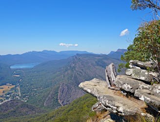
FATMAP by Strava

Mount Rosea Track

A challenging out-and-back trail that promises a good climb and spectacular view from the summit of Mount Rosea.

Hiking Moderate

Distance
7.7 km
Ascent
437 m
Descent
437 m
Duration
2-3 hrs
Low Point
607 m
High Point
998 m
Gradient
Mount Rosea Track Map

The Mount Rosea track is a challenging 7.7km hike that climbs up to the summit of Mount Rosea. The views are well worth the climb, with sights of the Grampians National Park and plenty of vantage points to see eagles flying below. It’s a fantastic day hike from an end of park camping site at Wungabringer Hill.

Description

The summit track begins at the car park off Stony Creek Road, heading through the bush for about 15 minutes before emerging above tree line. Hikers can choose to follow the old mining road (the Mount Rosea Track) or take the Mount Rosea Grand Staircase Track. Both trails become steeper until the reach its peak in the saddle below Mt Rosea itself.

Difficulty

Moderate

Hiking along trails with some uneven terrain and small hills. Small rocks and roots may be present.

Best time to visit

between September and May

Features

  • Wildlife
  • Picturesque
  • Summit Hike
  • Forestry or heavy vegetation

Similar routes nearby