3.6 km away
The Grampians Peaks Trail
A world-class, multi-day hike through the heart of one of Australia's national parks.
Extreme Hiking
- Distance
- 154 km
- Ascent
- 6.1 km
- Descent
- 6.1 km
A well-marked, but challenging trail that takes in some spectacular viewpoints in the Grampians.
Hiking Moderate

If you’re after a challenge, the Mount Stapylton Loop Walk is just the ticket. This 10km trail leads you up to some spectacular lookouts in the Grampians. The views are fantastic and it’s best to give yourself plenty of time to take in the sights and fully appreciate your surroundings.
The trail is well-marked, and popular for walkers and hikers alike. While it gets busy, it is possible to find quieter spots on the trail.
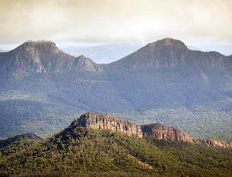
This hiking trail takes place within the Grampians National Park, which covers a vast area in western Victoria. This mountainous park has been carved out of ancient volcanic eruptions, with peaks steeped in history and mystery. With a stunning network of trails to choose from, be sure to take maps, food and water.
Moderate
Hiking along trails with some uneven terrain and small hills. Small rocks and roots may be present.
3.6 km away
A world-class, multi-day hike through the heart of one of Australia's national parks.
Extreme Hiking
4.1 km away

An easy walk up through the bush to the top of Hollow Mountain, with its views over the Mount Stapylton Ampitheatre.
Easy Hiking