22 m away
The Grampians Peaks Trail
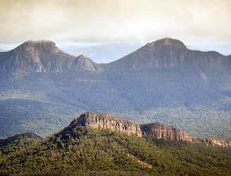
A world-class, multi-day hike through the heart of one of Australia's national parks.
Extreme Hiking
- Distance
- 154 km
- Ascent
- 6.1 km
- Descent
- 6.1 km
An easy out-and back walk to the summit of Mount Zero in the Grampians National Park.
Hiking Easy

This is a popular hiking route which is generally considered to be easy. It's not remote, it features unknown exposure and is typically done all year round. From a low point of 245 m to the maximum altitude of 360 m, the route covers 2.4 km, 122 vertical metres of ascent and 122 vertical metres of descent.
The starting point of the Grampians Peaks Trail, the Mount Zero walk is an easy (2.4km / one hour) hime to the summit of Mount Zero (394m). A well-marked trail, this family-friendly hike is popular with walkers looking for viewpoints in the local area.
Easy
Walking along a well-kept trail that’s mostly flat. No obstacles are present.

Close to help in case of emergency.
22 m away
A world-class, multi-day hike through the heart of one of Australia's national parks.
Extreme Hiking
856 m away

An easy walk up through the bush to the top of Hollow Mountain, with its views over the Mount Stapylton Ampitheatre.
Easy Hiking