5 km away
Panorama Trail + Monti Trail
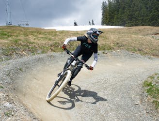
A route top to bottom, connecting two amazing flow trails!
Moderate Mountain Biking
- Distance
- 6.9 km
- Ascent
- 0 m
- Descent
- 766 m
Flowy run for all skill levels
Mountain Biking Extreme

It's headed from the east side of the middle station to the valley station of the Asitzbahn. This is a nice, pleasant trail, where you can test your skills before venturing into more challenging terrain. This trail leads directly from the middle station over an alpine meadow into the adjoining forest. There it heads into serpentines and continues up to the forest trail, from there it goes until you turn left into the Embachhalde. Cross the trail along the Leoganger Ache and return to the valley station of the Asitzbahn.
Extreme
Very steep, difficult, narrow singletrack with widely variable and unpredictable trail conditions. Unavoidable obstacles could be 15in/38cm tall or greater, and unavoidable obstacles with serious consequences are likely to be present. Obstacles could include big rocks, difficult root sections, drops, jumps, sharp switchbacks, and more. Ideal for expert-level riders.
5 km away
A route top to bottom, connecting two amazing flow trails!
Moderate Mountain Biking