
3.1 km away
Mount Smutwood
A great day hike with alpine lakes and stunning views.
Difficult Hiking
- Distance
- 18 km
- Ascent
- 954 m
- Descent
- 956 m
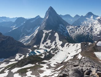
Views of Mount Assiniboine from Nub Peak
Hiking Difficult

Start at the Mount Shark Trailhead, take the Assiniboine Pass all the way to BR17. This is an easy 13 miles on flat, well maintained trails.
I camped at BR17. So on the way in, I went ahead and set up my tent and made lunch. This allowed me to shed weight right before the elevation gains started.
From BR17, you have two options: either the Upper Pass or the Lower Pass (the Horse Trail). The Upper was closed for me due to bear activity. The Lower pass wasn't scenic, was a rough trail, and has a worse gradient. Regardless, both trails end up converging a little before O'Brien Meadows. From here follow signs for Nub Peak.
The full summit of Nub Peak wasn't really worth it. The best views of Mount Assiniboine were from about halfway up.
I got to the summit around 3:30 and stayed for a little over an hour. Wish I could have stayed longer but didn't feel like returning to the campsite in the dark. I was also hiking alone. The hike back to BR17 was pretty much all downhill.
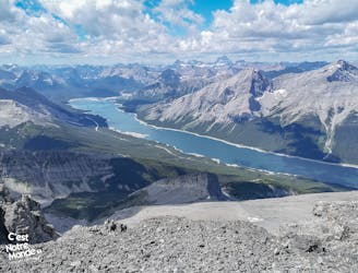
In the morning, I packed up and headed back up the Lower Pass. Hiking out via Wonder Pass is definitely the way to do it. You hike next to Marvel Lake for a good bit, and the scrambles are all downhill.
I did this hike in Early September, and most of the creeks had dried up. Especially near BR17 and on the Nub Peak Ascent. On the way in, I would recommend refilling at BR9, then again a little north of BR17. There are plenty of streams along Wonder Pass to refill at on the way out.
I did this hike in 17 hours, which doesn't include time spent at the summit. Started at 8AM, quick hike from Mount Shark Parking lot to BR17, where I set up for the night, dropped weight, and made lunch. I ran up to Nub Peak, spent some time on the summit, and made it back to BR17 by 7:30PM. Ended up being ~26 miles for the first day. Then another 20 for the hike out. If I did it again, I would probably break it up a little more, and spend at least two nights out there.
Labeling it as very remote, more because I did it solo and didn't see anyone for most of the first day; but realistically there is a helicopter service that runs to Mount Assiniboine Lodge, and if you do need a quick way out that is a nice option to have.
Views were worth it. Trekking Poles recommended.
Difficult
Hiking trails where obstacles such as rocks or roots are prevalent. Some obstacles can require care to step over or around. At times, the trail can be worn and eroded. The grade of the trail is generally quite steep, and can often lead to strenuous hiking.

The trail contains some obstacles such as outcroppings and rock which could cause injury.

Little chance of being seen or helped in case of an accident.
3.1 km away
A great day hike with alpine lakes and stunning views.
Difficult Hiking
9.8 km away
Conquering Great Heights: Ascending Mount Sparrowhawk's Iconic Route
Difficult Hiking