6.9 km away
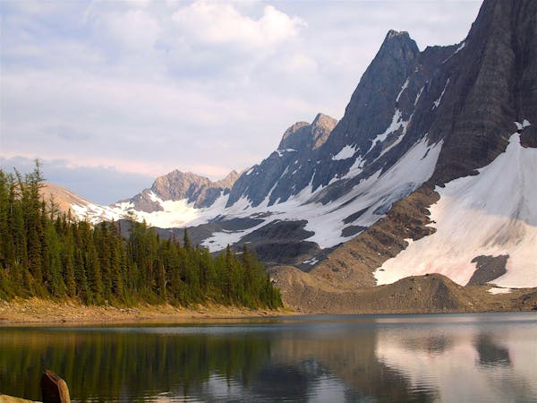
Kindersley Pass - Sinclair Creek Loop

A plethora of views and a backcountry feel, packed into a concise but challenging loop from the highway.
Difficult Hiking
- Distance
- 17 km
- Ascent
- 1 km
- Descent
- 1 km
Forest hike with scenic overlooks, leading to waterfalls hidden in a narrow gorge.
Hiking Moderate

Just inside Kootenay National Park’s west entrance, the highway squeezes narrowly between rock walls. It resembles a constructed passage, but is actually the natural course of Sinclair Creek, through a slot canyon. The creek is diverted beneath the roadway, but then emerges and tumbles through a lower gorge in several small waterfalls, which you can reach by hiking Juniper Trail.
The trail begins at Radium Hot Springs, from the main parking area. It goes up a lightly forested hillside, soon reaching an excellent view over the park entrance and the Columbia River Valley. It then descends quite a few switchbacks and comes to the creek in its rocky corridor, where side trails lead to secluded spots along the bank. Down by the water, the highway noise fades and you are left with the tranquility of falling water in nature.
The full hike from Radium Hot Springs is what’s mapped here, but there’s a separate trailhead for Sinclair Canyon, which you can use to reach the falls more quickly and skip the rest of the hike if you like. Access is beside the highway just after entering the park’s West Gate, but space is limited at that parking area.
Source: https://www.pc.gc.ca/en/pn-np/bc/kootenay/activ/randonnee-hike/courte-short
Moderate
Hiking along trails with some uneven terrain and small hills. Small rocks and roots may be present.

The trail contains some obstacles such as outcroppings and rock which could cause injury.

Close to help in case of emergency.
6.9 km away
A plethora of views and a backcountry feel, packed into a concise but challenging loop from the highway.
Difficult Hiking
5 routes · Hiking