10 m away
Twisted Sisters
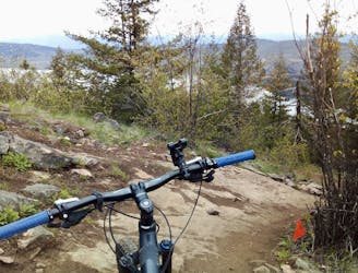
An easy warmup leads to a steep climb and a fun, flowing descent.
Difficult Mountain Biking
- Distance
- 14 km
- Ascent
- 524 m
- Descent
- 523 m
The bike leg of the Aerothlon Vernon BC Canada
Mountain Biking Difficult

This is a popular mountain biking route which is generally considered to be difficult. It's remote, it features medium exposure and is typically done between April and November. From a low point of 444 m to the maximum altitude of 585 m, the route covers 19 km, 390 vertical metres of ascent and 390 vertical metres of descent.
Gorgeous bike ride from the LZ King Eddy paragliding site to Kalamalka Park and return by scenic road in the beautiful Okanagan valley
Difficult
Mostly stable trail tread with some variability featuring larger and more unavoidable obstacles that may include, but not be limited to: bigger stones, roots, steps, and narrow curves. Compared to lower intermediate, technical difficulty is more advanced and grades of slopes are steeper. Ideal for upper intermediate riders.

The trail contains some obstacles such as outcroppings and rock which could cause injury.
Away from help but easily accessed.
10 m away
An easy warmup leads to a steep climb and a fun, flowing descent.
Difficult Mountain Biking