4.8 km away
Flatiron East Face
A stunning journey to a beautiful ski face
Difficult Ski Touring
- Distance
- 11 km
- Ascent
- 1.2 km
- Descent
- 1.2 km
conservative little tour
Ski Touring Easy

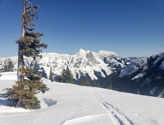
This is a popular ski touring route which is generally considered to be easy. It's remote, it features medium exposure (e2) and is typically done between December and March. From a low point of 1.2 km to the maximum altitude of 1.9 km, the route covers 7.7 km, 762 vertical metres of ascent and 761 vertical metres of descent. You'll need skins to complete it safely.
Greta views on a clear day!
Easy
Wide gentle slopes at around 20 degrees or less.

As well as the slope itself, there are some obstacles (such as rock outcrops) which could aggravate injury.
Away from help but easily accessed.
4.8 km away
A stunning journey to a beautiful ski face
Difficult Ski Touring