362 m away
Le lac crossing

A long traverse line with a little bit of steepness into a forest area.
Severe Freeride Skiing
- Distance
- 1 km
- Ascent
- 10 m
- Descent
- 292 m
A shortcut following a track into the forest.
Freeride Skiing Easy

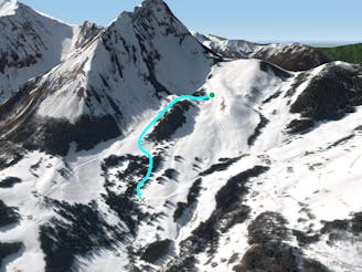
This is an easy access line by the bottom of the ski lift "Le Lac" on the left of the bottom of blue slope. The line is not steep and can feel like a piste but there are some stones all along the track and trees as soon as a mistake is done from the track. The line is pretty low in altitude so make sure there's enough snow before heading in. Avalanche risk is pretty low around here but one unusual hazard to be aware of on this line are the fences of fields owner, remember a river crossing is present mostly at the beginning of the run. The line finishes on the blue piste "Retour Village" which leads back to the bottom of the ski resort.
Easy
Wide gentle slopes at around 20 degrees or less.

As well as the slope itself, there are some obstacles (such as rock outcrops) which could aggravate injury.

Little chance of being seen or helped in case of an accident.
362 m away
A long traverse line with a little bit of steepness into a forest area.
Severe Freeride Skiing
495 m away

A tree line under the gondolas where trees are the main risk, especially with poor snow cover.
Difficult Freeride Skiing
796 m away

The steepest line around which is only for experts. A fall might kill you and rescue is really complicated.
Extreme Freeride Skiing
881 m away
Small isolated line passing by a small and forest.
Severe Freeride Skiing
1.1 km away

A long out of slope line without major difficulties.
Moderate Freeride Skiing
1.1 km away

A nice short cut line where trees mark the middle of the line.
Difficult Freeride Skiing
1.1 km away

A nice shortcut with some trees and a bit of steepness.
Difficult Freeride Skiing
1.2 km away

A really steep gully between trees and some long traverse as ending.
Extreme Freeride Skiing
1.3 km away

A small shortcut line alongside the "Corne II" ski lift where good snow can be found.
Difficult Freeride Skiing
1.3 km away

Easy access forest line with some tree skiing.
Difficult Freeride Skiing