1.9 km away
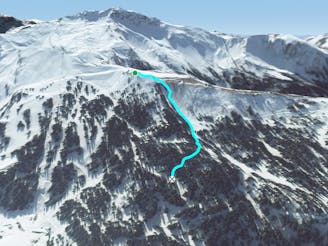
Les Hauts Forts: North Face

Bag a summit and enjoy an enormous off-piste face with a variety of lines in close proximity to the resort.
Severe Freeride Skiing
- Distance
- 3 km
- Ascent
- 39 m
- Descent
- 1 km
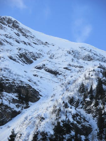
Magnificent and very steep couloir on the north side of Ressachaux.
Freeride Skiing Extreme

Take the road from Morzine to Prodains and stop at the Covagnes car park (1,160m). From Covagnes, begin your hike up the trail leading to the southwest through the Acquv woods to reach the 1,421m point marked on the map. Ascend below the northeast face to reach the bottom of the couloir. Climb up the couloir and if possible onto the ridge at the top (the way onto the ridge is often blocked by an enormous cornice). Climb to the summit and descend via the same route.
This is a challenging route with slopes reaching 50° and is often not in condition until later in the season once the whole couloir has filled with snow. However, by this point the cornice has built up at the top and often becomes impassable, so it is very difficult to make the full ascent and descent incorporating the summit.
Alternatively you can approach via the lifts using Les Hauts Forts freeride line.
Extreme
Extreme skiing terrain above 45 degrees. These routes are reserved for experienced experts.

As well as the slope itself, there are some obstacles (such as rock outcrops) which could aggravate injury.

Little chance of being seen or helped in case of an accident.
1.9 km away
Bag a summit and enjoy an enormous off-piste face with a variety of lines in close proximity to the resort.
Severe Freeride Skiing
2.3 km away

This steep couloir is a slightly easier descent than its neighbour.
Severe Freeride Skiing
3.2 km away

A long line below and then over a ridge with some steepness and a mix of snow conditions.
Extreme Freeride Skiing
3.2 km away

Little walk needed to enter a steep and sunny line.
Extreme Freeride Skiing
3.3 km away

Easy and gentle line close the trees.
Easy Freeride Skiing
3.6 km away

Warm up playground.
Difficult Freeride Skiing
3.6 km away

A ice long line giving some steepness and some tree skiing which requires good skills.
Severe Freeride Skiing
3.6 km away
Secluded forest playground.
Difficult Freeride Skiing
3.7 km away

A legendary couloir known to be popular with the local ski patrol, for expert skiers only.
Severe Freeride Skiing
3.8 km away

Lift accessed area classic with a free bus ride back to Morzine.
Moderate Freeride Skiing

18 routes · Freeride Skiing
9 routes · Freeride Skiing · Ski Touring