3.3 km away
Swiss Side Loop
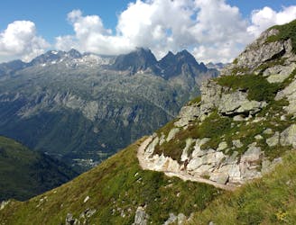
From Le Tour, visit Trient and return along the CCC/UTMB course before discovering the Posettes ridgeline.
Severe Trail Running
- Distance
- 25 km
- Ascent
- 2.2 km
- Descent
- 2.2 km
Boucle sauvage à la Loriaz
Trail Running Moderate

This is a popular trail running route which is generally considered to be moderate. It's remote, it features medium exposure and is typically done between June and October. From a low point of 1.4 km to the maximum altitude of 2.6 km, the route covers 16 km, 1351 vertical metres of ascent and 1364 vertical metres of descent.
Depart du Couteray, montée par le refuge de la Loriaz, col de la Terrasse, et descente par le vallon sauvage de tré-les-eaux.
Moderate

The trail contains some obstacles such as outcroppings and rock which could cause injury.
Away from help but easily accessed.
3.3 km away
From Le Tour, visit Trient and return along the CCC/UTMB course before discovering the Posettes ridgeline.
Severe Trail Running
3.4 km away

Une course dédiée aux jeunes !
Moderate Trail Running
9.5 km away
A short loop on one of the best sections of the Petit Balcon Sud trail.
Easy Trail Running
9.5 km away
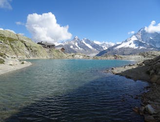
Link four lakes together while enjoying the view of the Chamonix valley.
Severe Trail Running

8 routes · Trail Running