76 m away
Kv du Mont-Blanc

le kilomètre vertical de Chamonix
Difficult Trail Running
- Distance
- 3.9 km
- Ascent
- 1 km
- Descent
- 0 m
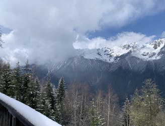
Cette boucle d'un peu moins de 6 kilomètres au cœur de la vallée de Chamonix est un parcours facile qui vous permettra de profiter des beaux paysages de la vallée. This loop of just under 6 kilometers in the heart of the Chamonix valley is an easy route allowing you to enjoy the beautiful landscapes of the valley.
Trail Running Easy

This is a popular trail running route which is generally considered to be easy. It's an unknown remoteness, it features unknown exposure and is typically done in an unknown time of year. From a low point of 1 km to the maximum altitude of 1.1 km, the route covers 9.1 km, 121 vertical metres of ascent and 121 vertical metres of descent.
Easy
76 m away
le kilomètre vertical de Chamonix
Difficult Trail Running
99 m away

Epreuve reine de l'événement
Severe Trail Running
108 m away

La course nocturne en binome
Difficult Trail Running
114 m away

La plus longue coure du Marathon
Extreme Trail Running
282 m away
An amazing way to see some of the best view in Chamonix on foot.
Moderate Trail Running
770 m away

A classic loop around the Chamonix Valley.
Easy Trail Running
923 m away

La course format 10k de l'événement
Moderate Trail Running
944 m away

le cross du Mont-blanc
Difficult Trail Running
957 m away

Le mini cross est un petit trail pour les plus jeunes, de 800m à 3km en fonction des catégories.
Easy Trail Running
977 m away
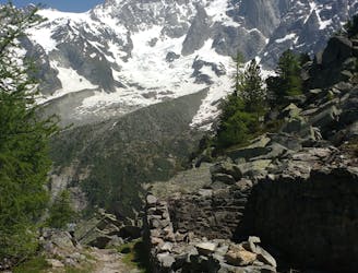
Enjoy the open vistas of the north balcony between Montenvers and Plan de l'Aiguille on vintage Chamonix trails.
Moderate Trail Running

8 routes · Trail Running