137 m away
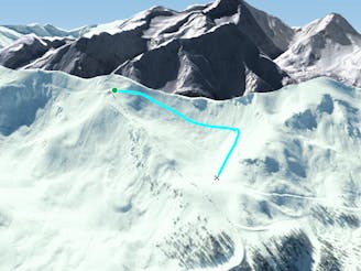
Couis 1 Top To Bottom

Another route running next to the piste but chance to enjoy some jumps, small ridges and race your friends.
Moderate Freeride Skiing
- Distance
- 954 m
- Ascent
- 0 m
- Descent
- 374 m
This run is fast, fun and steep. Not to far from the beaten track but an extremely interesting area of terrain. Taking advantage of Pila's secret spots
Freeride Skiing Difficult

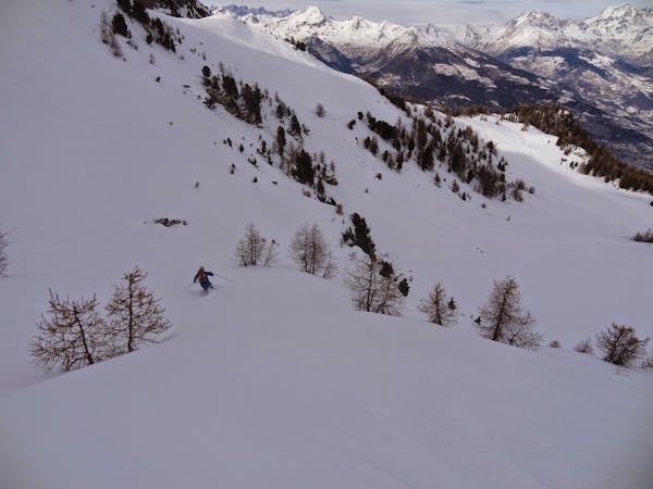
This route is clouded in a little bit of mystery. Like all good freeride spots, there are stories or danger and bad decisions. Where unsuspecting tourists have taken to the off piste ill-equipped in mind and in safety measures BUT for the cool, calm and collected free riders out there, this route is a fantastic warm up choice. It can be done in little over an hour from lift to lift. To begin, take the Couis 1 lift. Get off the chair lift on the left. Take advantage of the killer views from the top of the lift then you can smugly pass all the people heading onto red 9. As the path to red 9 is on your left, you begin to traverse out to skiers right. The area at first is steep so you will drift down as well as out to the right. It takes you into a basin of sorts with the piste to your not so distant left and rocks and the promise of exciting new pastures on your right. When you have established yourself comfortably in the basin then you can begin to descend. If the snow moves in the area, it will move quickly- this is certainly a chance for you to employ the one by one system. There are a few ridges on the right to use as take offs and the area is nice and steep. When the snow is good, there will be may a powder turn to enjoy. However, this route is still good training on the legs when it's hard packed or slightly icy. In fact, its good to play with your technique in varied conditions and this route is a good area for the aspiring back country skiers or snowboarders. As you descend you will see less of red 9 and begin to see the side of black 8. You can use this as a guide to help you navigate back to the safety of the piste as you see black 8 and black 27 meet red 9. No climbing equipment is needed for this route, simply the traverse will allow you to access this particular spot.
Difficult
Serious gradient of 30-38 degrees where a real risk of slipping exists.

In case of a fall, death is highly likely.

Away from help but easily accessed.
137 m away
Another route running next to the piste but chance to enjoy some jumps, small ridges and race your friends.
Moderate Freeride Skiing
821 m away

Short but very sweet. Down one of the steepest routes in valley
Difficult Freeride Skiing
836 m away
This is a classic option not explored enough. SO MANY OPTIONS
Moderate Freeride Skiing
966 m away

Fun, thrilling, jumps, bumps and plenty of chances to show off
Difficult Freeride Skiing
2.6 km away

A little run for beginners to enjoy a few hundred meters of quiet terrain
Easy Freeride Skiing

50 routes · Freeride Skiing · Ski Touring
5 routes · Freeride Skiing · Ski Touring