6.6 km away
Approach to the Rothorn Hut
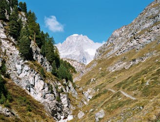
A tough climb from a classic alpine village to a classic alpine hut.
Difficult Hiking
- Distance
- 7.4 km
- Ascent
- 1.6 km
- Descent
- 18 m
Gandeghütte - Breithorn - Trockener Stegg
Also in Valais, Switzerland
Hiking Severe

This is a popular hiking route which is generally considered to be severe. It's extremely remote, it features high exposure and is typically done between July and September. From a low point of 3 km to the maximum altitude of 4.2 km, the route covers 11 km, 1160 vertical metres of ascent and 488 vertical metres of descent.
Gandeghütte - Breithorn - Trockener Stegg
Severe
Hiking challenging trails where simple scrambling, with the occasional use of the hands, is a distinct possibility. The trails are often filled with all manner of obstacles both small and large, and the hills are very steep. Obstacles and challenges are often unexpected and can be unpredictable.

Some trail sections have exposed ledges or steep ascents/descents where falling could cause serious injury.

In the high mountains or remote conditions, all individuals must be completely autonomous in every situation.
6.6 km away
A tough climb from a classic alpine village to a classic alpine hut.
Difficult Hiking
8.6 km away
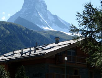
A downhill stroll into Zermatt past some epic scenery.
Moderate Hiking

9 routes · Alpine Climbing · Hiking

20 routes · Alpine Climbing · Hiking