30 m away
Tre Cime Circuit
A beautiful loop around the most famous mountains in the Dolomites - The Tre Cime
Moderate Hiking
- Distance
- 9.7 km
- Ascent
- 439 m
- Descent
- 439 m
Cadini di Misurina - Paternkofel (via ferrata) - Sextenstein
Hiking Difficult

An adventurous tour crossing some of the Tre Cime national park's most scenic spots. Mix between mountain hike and via ferrata. (personal track)
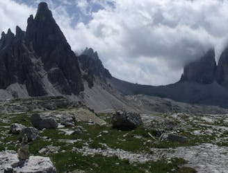
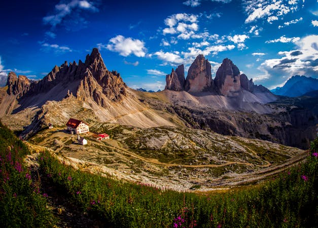
Tour: arrived at 8:20am at Rifugio Auronzo. Starting the hike to your right towards Cadini di Misurina, the famous viewpoint, which is the nicest in the morning sun. Usually this spot is calmer with less tourists, but it can occur that some lovebirds hog the place for instagram pics. After the viewpoint you return the same way to Rifugio Auronzo to start the hike towards Paternsattel. This path is very broad with a slight incline at the end. On Paternsattel you start on your right the ascent to Paternkofel. The way can be tricky if your not sure on your feet, have a fear of heights and have claustrophobia. Also time to take out your via ferrata gear (note that this hike can be busy). On the ascent you also encounter a nice lookout to the three peaks. The last bit to the top has some climbing passages. After Paternkofel and enjoying the view you can descent to the left towards Drei Zinnenhütte. The descent is pretty adventurous it has some climbing passages and you go through some long world war 1 tunnels (bring a headlight!). At the Dreizinnenhütte you can pause and eat/drink, they have great food! After that you can go up to Sextener Stein, where you have a wonderful view and much less tourists. There is a sign saying "Via Ferrata Toblinger Knoten" but it also leads to the viewpoint. Then you can start your return back to Rifugio Auronzo
Difficult
Hiking trails where obstacles such as rocks or roots are prevalent. Some obstacles can require care to step over or around. At times, the trail can be worn and eroded. The grade of the trail is generally quite steep, and can often lead to strenuous hiking.

Some trail sections have exposed ledges or steep ascents/descents where falling could cause serious injury.

Away from help but easily accessed.
30 m away
A beautiful loop around the most famous mountains in the Dolomites - The Tre Cime
Moderate Hiking
3 routes · Hiking
6 routes · Mountain Biking · Hiking