9.1 km away
Lago di Pilato from Foce
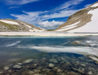
A gorgeous, yet moderately-strenuous, climb to the magical, mysterious, and only natural lake in Le Marche.
Difficult Hiking
- Distance
- 12 km
- Ascent
- 1 km
- Descent
- 1 km
Escursioni Alta Quota 11
Hiking Severe

Da Nocelleto a Madonna della Cona
Il percorso abbraccia un’area resa particolarmente interessante anche per la recente reintroduzione del cervo che, con un progetto del Parco, è tornato a vivere dopo oltre 200 anni sui Sibillini. L'itinerario si sviluppa attraverso la Valle di Corveto per raggiungere la Madonna della Cona da cui si può ammirare il Pian Perduto di Castelluccio, il gruppo del Monte Vettore ed il M. Lieto.
Severe
Hiking challenging trails where simple scrambling, with the occasional use of the hands, is a distinct possibility. The trails are often filled with all manner of obstacles both small and large, and the hills are very steep. Obstacles and challenges are often unexpected and can be unpredictable.

Some trail sections have exposed ledges or steep ascents/descents where falling could cause serious injury.
Little chance of being seen or helped in case of an accident.
9.1 km away
A gorgeous, yet moderately-strenuous, climb to the magical, mysterious, and only natural lake in Le Marche.
Difficult Hiking