780 m away
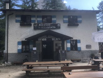
Pradèl - Rif. Selvata - Molveno
A trek for everyone to taste the Brenta Dolomites!
Moderate Hiking
- Distance
- 12 km
- Ascent
- 668 m
- Descent
- 1.1 km
Bus / car to molveno village. From village take up two cablecars to La Montanara (top of bikepark). Start steep ascend to croz d'altissimo through forest. Reach croz after technical last 200m. Go back same 200m until crossing with direction to Rifugio d'altissimo. About 1000m of technical descend. From Rifugio, elevation stays about the same till you reach Pradel cable car (bike park low point). Took us 6 hour total, with some rest, 30 minute stop at croz, and 20 minute stop at Rifugio. Challenging, but stunning day-trail
Hiking Difficult

Bus / car to molveno village. From village take up two cablecars to La Montanara (top of bikepark). Start steep ascend to croz d'altissimo through forest. Reach croz after technical last 200m. Go back same 200m until crossing with direction to Rifugio d'altissimo. About 1000m of technical descend. From Rifugio, elevation stays about the same till you reach Pradel cable car (bike park low point). Took us 6 hour total, with some rest, 30 minute stop at croz, and 20 minute stop at Rifugio. Challenging, but stunning day-trail.


Difficult
Hiking trails where obstacles such as rocks or roots are prevalent. Some obstacles can require care to step over or around. At times, the trail can be worn and eroded. The grade of the trail is generally quite steep, and can often lead to strenuous hiking.

The trail contains some obstacles such as outcroppings and rock which could cause injury.

Close to help in case of emergency.
780 m away
A trek for everyone to taste the Brenta Dolomites!
Moderate Hiking