11 m away
Kozan no sawa (variation)

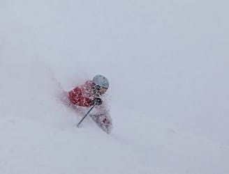
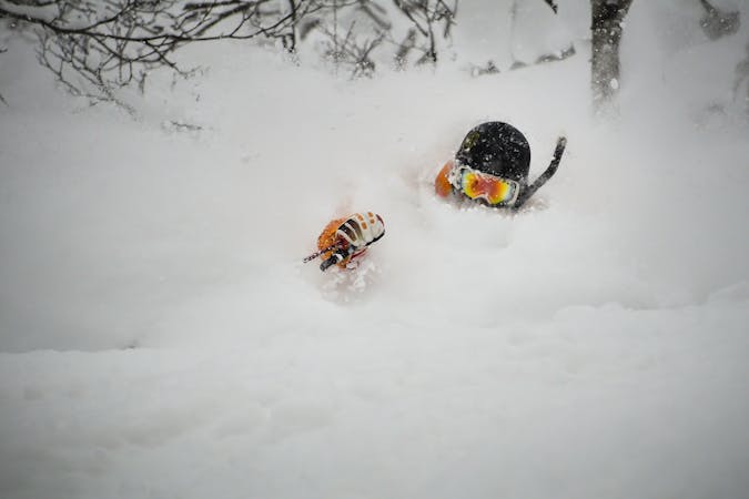
A 20 minute hike above the resort out of Gate 3, this line is a truly classic Niseko back bowl run.
Difficult Freeride Skiing
- Distance
- 2.1 km
- Ascent
- 0 m
- Descent
- 673 m
A 20 minute hike above the resort out of Gate 3, this line is in the back bowls of Niseko and requires you to hike out.
Freeride Skiing Difficult

A classic hike-to line in the legendary Niseko back bowls. Perfect after a storm day. Be sure to check the Nadare forecast (linked below) for avalanche conditions and gate openings.
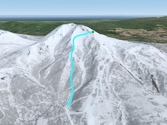
Access is via the Niseko-Annupuri Summit Hike, through Gate 3. From the King Lift 4, the gate is just above the summit station. From the Ace Pair Lift 4, traverse hard to the riders left to reach the King Lift 4 summit station. This line is also accessible from Gate 2, by continuing down from the Annupuri summit, to the right along the col above Gate 3, though most skiers access this line via Gate 3 so they don't have to walk downhill.
After exiting Gate 3, follow the Niseko-Annupuri Summit Hike, a bootpack along a cat track, until reaching the col. Continue to the right while enjoying stunning views of the surrounding peaks including Io, Konbu, and Yotei. The ocean is also visible from here on particularly clear days. You will know you are at the correct summit because there is a small hut at the top of Niseko-Annupuri, as well as a weather station. It is usually windy here, and this is a great place to take shelter while grabbing a drink and a snack before your descent. Treat the hut with respect by carrying out your own trash and trying to keep snow out please!
This descent starts out similar to the Kozan no Sawa variation. Ski along the SW ridge from the hut. Be wary, this ridge is frequently wind scoured and is full of holes from eroded, rotten snow, or thermal activity. Be cautious to not get too close to the ridge later in the season as the cornice gets bigger. Stay to the riders right of the nose: the dominant feature at the end of the SW ridge. Coming around the side of it, rather than cutting back towards the riders left, simply drop in. Much like many runs in Niseko, this is a riders delight. The most frequently skied route is highlighted on the map. The line visibly takes a left at the top before committing to the fall line. One can cut instead to the right and find some beautiful, open tree skiing all the way to Route 58. It is also possible to stay to the left and follow the ridge until fresh tracks are found before dropping in. This is a common strategy later in the day when the primary lines are tracked out.
This run is frequently linked up with Io Dake as a full day out back. Parking is free at Goshikionsen which organised groups and guides frequently take advantage of. If you are unable to organise a car ahead of time, the onsen has a phone and one can call for a taxi at the lot, though it is recommended to organise the appropriate resources at the parking lot ahead of time. Skins are recommended for the return, especially if there is an ample amount of fresh snow or there are snowboarders in the party.
Difficult
Serious gradient of 30-38 degrees where a real risk of slipping exists.

Exposure is limited to that of the slope itself. Getting hurt is still likely if the slope is steep and/or the snow is hard.

In the high mountains or remote conditions, all individuals must be completely autonomous in every situation.
11 m away
A 20 minute hike above the resort out of Gate 3, this line is a truly classic Niseko back bowl run.
Difficult Freeride Skiing
16 m away

A 20 minute hike above the resort out of Gate 3, this line is in the back bowls of Niseko and requires a hike out.
Difficult Freeride Skiing
28 m away
A 20 minute hike above the resort out of Gate 3, this line is a classic Niseko back bowl run.
Difficult Freeride Skiing
29 m away

A 20 minute hike above the resort out of Gate 3, this line is in the back bowls of Niseko and requires a short hike out.
Moderate Freeride Skiing
341 m away

A 20 minute hike above the resort out of Gate 2, this line is a classic Niseko back bowl run.
Difficult Freeride Skiing
470 m away

G3 is one of two of the essential hikes leading to the legendary Niseko Back Bowls
Difficult Freeride Skiing
624 m away

Upper mountain gate access (Gate 5) skiing with steeper gradients and a variety of tree densities with minimal hiking.
Difficult Freeride Skiing
727 m away

G2 is one of two of the essential hikes leading to the legendary Niseko Back Bowls
Difficult Freeride Skiing
732 m away
Upper mountain gate access skiing with interesting ridge features, steeper gradients, and a variety of tree densities with minimal hiking.
Moderate Freeride Skiing
742 m away

Great powder gully skiing popular with intermediate off piste skiers.
Moderate Freeride Skiing
12 routes · Freeride Skiing