26 m away
Old Ghost Road - IMBA Epic
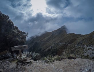
A long and epic - but never overly technical - journey through some wild terrain.
Difficult Mountain Biking
- Distance
- 80 km
- Ascent
- 2.9 km
- Descent
- 3 km
Old Ghost Road
Mountain Biking Difficult

This is a popular mountain biking route which is generally considered to be difficult. It's an unknown remoteness, it features unknown exposure and is typically done in an unknown time of year. From a low point of 30 m to the maximum altitude of 1.3 km, the route covers 79 km, 3003 vertical metres of ascent and 3090 vertical metres of descent.
Big day of riding with lots of verticle climbing
Difficult
Mostly stable trail tread with some variability featuring larger and more unavoidable obstacles that may include, but not be limited to: bigger stones, roots, steps, and narrow curves. Compared to lower intermediate, technical difficulty is more advanced and grades of slopes are steeper. Ideal for upper intermediate riders.
26 m away
A long and epic - but never overly technical - journey through some wild terrain.
Difficult Mountain Biking