146 m away
Melkefjellet West (1266m)
An attractive alternative to the popular main summit
Difficult Ski Touring
- Distance
- 11 km
- Ascent
- 1.1 km
- Descent
- 1.1 km
Classic early season top. Start on skis from carpark and uphill through forest, traverse and ridge up to the top.
Ski Touring Moderate

This is a popular ski touring route which is generally considered to be moderate. It's remote, it features medium exposure (e2) and is typically done between November and May. From a low point of 359 m to the maximum altitude of 1.5 km, the route covers 9.9 km, 1173 vertical metres of ascent and 1173 vertical metres of descent. You'll need skins to complete it safely.


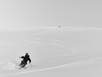
Early season with thin snow cover. The downhill track follows a steeper downhill alternative to skiing the skin track down. Be aware finding the last gully can be challenging. Safer skiing by following the uphill track
Moderate
Slopes become slightly steeper at around 25-30 degrees.

As well as the slope itself, there are some obstacles (such as rock outcrops) which could aggravate injury.
Away from help but easily accessed.
146 m away
An attractive alternative to the popular main summit
Difficult Ski Touring

20 routes · Freeride Skiing · Ski Touring