442 m away
Directa's line

Short cut lines between slopes.
Difficult Freeride Skiing
- Distance
- 552 m
- Ascent
- 0 m
- Descent
- 175 m
A quick line which is easy to reach from the blue slopes and not too steep.
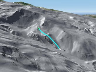
Freeride Skiing Difficult

From the Gondolas or at the same height, easily cut from the slopes without any walk needed. The face is usually either wet or frozen due to the huge quantity of sun it receives. Snow cover on this side is not huge as a result of the sun. Instead of carrying on with the blue slope, this short cut will help to join the bottom section of the ski resort. Be aware that there can be a lot of people at the bottom of the run and do not forget that you cross some small rivers, which can be rocky. Speed won't be huge as the blue slope used to enter in the run is not steep at all. The best time to ski it is after some fresh snow fall and then you can hit the run, check the snow cover as when there is not any base at the beginning of the season this run is not best choice of line. Some nice time can be found and this area will save you a lot queuing in the blue slope and a gain of time. The blue slope faces due south-west will have with some sticky snow and some Nordic style skills are needed to join the skis resort as the track is quite flat. In case of good snow conditions some little rocks can be jumped along the run.
Difficult
Serious gradient of 30-38 degrees where a real risk of slipping exists.

As well as the slope itself, there are some obstacles (such as rock outcrops) which could aggravate injury.
Away from help but easily accessed.
442 m away
Short cut lines between slopes.
Difficult Freeride Skiing
548 m away
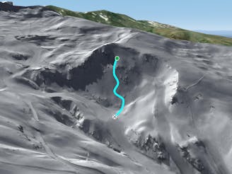
A shortcut between black slopes on an ridge for experienced and skilled skiers.
Difficult Freeride Skiing
643 m away

Great total freeriding line between cliffs, steepness, rocks and often some good snow for only experts.
Extreme Freeride Skiing
666 m away

Different approach to the stadium line, but also steep.
Severe Freeride Skiing
673 m away

A hiking line where few turns can be done into a wild area.
Severe Freeride Skiing
683 m away

Technical line with optional cliff.
Severe Freeride Skiing
707 m away

Experienced skiers will be here as you can take the run really gentle,or taking the cliff.
Severe Freeride Skiing
729 m away

Shortcut between slopes with rocks as main hazards.
Moderate Freeride Skiing
780 m away
A long and really nice line well protected from the sun.
Severe Freeride Skiing
859 m away

A steep and short line between 2 black slopes below a ridge.
Severe Freeride Skiing