312 m away
Way home line
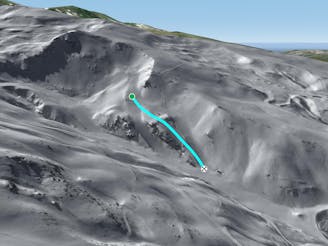
A shortcut between black slopes on an ridge for experienced and skilled skiers.
Difficult Freeride Skiing
- Distance
- 438 m
- Ascent
- 0 m
- Descent
- 159 m
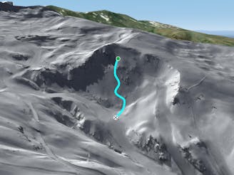
A steep and short line between 2 black slopes below a ridge.
Freeride Skiing Severe

Easily accessed line from black slope "Neveros" turn left 50 meters after the start of this slope. The line is into steep terrain between 2 black slopes below a little ridge with some rocks in it. Low snow cover can be often present here due to the low altitude. The line is usually shady due to the NE aspect and good snow can be often be found. The avalanche risk can be pretty high around here, particularly after heavy snow, due to the steepness. The line finishes on the blue piste "El Rio" which leads back to the bottom of the ski resort.
Severe
Steep skiing at 38-45 degrees. This requires very good technique and the risk of falling has serious consequences.

As well as the slope itself, there are some obstacles (such as rock outcrops) which could aggravate injury.
Away from help but easily accessed.
312 m away
A shortcut between black slopes on an ridge for experienced and skilled skiers.
Difficult Freeride Skiing
480 m away
A long and really nice line well protected from the sun.
Severe Freeride Skiing
554 m away

Nice long line mixing steepness and wild terrain.
Severe Freeride Skiing
587 m away

Line between black slopes, with steep entrance and real avalanches risk
Severe Freeride Skiing
610 m away

Mostly an under chairlift line where rocks and the lack of snow might an issue.
Difficult Freeride Skiing
815 m away

Great total freeriding line between cliffs, steepness, rocks and often some good snow for only experts.
Extreme Freeride Skiing
849 m away

Technical line with optional cliff.
Severe Freeride Skiing
859 m away

A quick line which is easy to reach from the blue slopes and not too steep.
Difficult Freeride Skiing
898 m away

Easily accessed line close the piste.
Difficult Freeride Skiing
903 m away

Different approach to the stadium line, but also steep.
Severe Freeride Skiing