126 m away
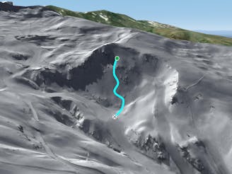
Montebajo's 2 traverse line

Nice long line mixing steepness and wild terrain.
Severe Freeride Skiing
- Distance
- 545 m
- Ascent
- 5 m
- Descent
- 90 m
Line between black slopes, with steep entrance and real avalanches risk
Freeride Skiing Severe

This line needs 10-15 minutes’ walk from the top of the Chairlift Montebajo. No skins are needed- it's more like a gentle walk, everything is quiet well groomed. The entrance is at the top of the small peak close the fence. Most of the time there is no sun in this area, snow will be well protected what mean fresh powder can be found often. If it has rained here then the entrance can be really tricky due some ice on the face; there are also small rocks everywhere on this side of the mountain. There is a really a long wooden fence which you keep on your left. We are aiming to stay close the fences to reach the intersection of black slopes named "Tubo del enebro" and the " Fuente del Tesoro" where you can choose one of these 2 black slopes to join the blue slope "El rio", bringing you back to the village and the gondola's. Remember in case of lack of snow a lot of rocks will appear everywhere.
Severe
Steep skiing at 38-45 degrees. This requires very good technique and the risk of falling has serious consequences.

As well as the slope itself, there are some obstacles (such as rock outcrops) which could aggravate injury.
Away from help but easily accessed.
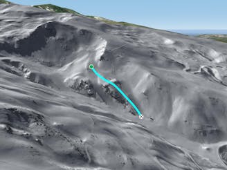
126 m away
Nice long line mixing steepness and wild terrain.
Severe Freeride Skiing
127 m away
A long and really nice line well protected from the sun.
Severe Freeride Skiing
142 m away

Mostly an under chairlift line where rocks and the lack of snow might an issue.
Difficult Freeride Skiing
390 m away

Great total freeriding line between cliffs, steepness, rocks and often some good snow for only experts.
Extreme Freeride Skiing
397 m away

Technical line with optional cliff.
Severe Freeride Skiing
441 m away

A quick traverse line between rocks in a relatively gentle area
Moderate Freeride Skiing
444 m away

Experienced skiers will be here as you can take the run really gentle,or taking the cliff.
Severe Freeride Skiing
466 m away

Different approach to the stadium line, but also steep.
Severe Freeride Skiing
585 m away
A shortcut between black slopes on an ridge for experienced and skilled skiers.
Difficult Freeride Skiing
587 m away

A steep and short line between 2 black slopes below a ridge.
Severe Freeride Skiing