886 m away
Way home line
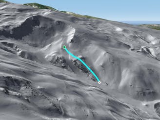
A shortcut between black slopes on an ridge for experienced and skilled skiers.
Difficult Freeride Skiing
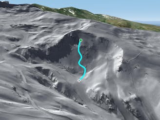
- Distance
- 438 m
- Ascent
- 0 m
- Descent
- 159 m
Easily accessed line close the piste.
Freeride Skiing Difficult

Take the "Jara" chairlift and turn left 20 meters after "Loma Dílar" blue and "Variante Puente" red pistes junction. The line is not steep and can feel like a piste but there are some rocks about if there is low snow cover. The line is well protected from the a lot of sun so make sure there's enough snow before heading in. Avalanche risk is pretty low around here due to the lack of snow. An unusual hazard is the big quantity of artificial snow what make the run passing from "slow" snow to natural snow. The line finishes on the walking area "Circuito de Prado Redondo" which leads back to the village.
Difficult
Serious gradient of 30-38 degrees where a real risk of slipping exists.

As well as the slope itself, there are some obstacles (such as rock outcrops) which could aggravate injury.
Away from help but easily accessed.
886 m away
A shortcut between black slopes on an ridge for experienced and skilled skiers.
Difficult Freeride Skiing
898 m away

A steep and short line between 2 black slopes below a ridge.
Severe Freeride Skiing
1.1 km away

Short cut lines between slopes.
Difficult Freeride Skiing
1.1 km away

A quick line which is easy to reach from the blue slopes and not too steep.
Difficult Freeride Skiing
1.2 km away

Line alongside a red slope however steepness is present and technical skills required.
Severe Freeride Skiing
1.3 km away

Rocky line right above the village.
Extreme Freeride Skiing
1.3 km away
A long and really nice line well protected from the sun.
Severe Freeride Skiing
1.4 km away

Nice long line mixing steepness and wild terrain.
Severe Freeride Skiing
1.4 km away

Line between black slopes, with steep entrance and real avalanches risk
Severe Freeride Skiing
1.5 km away

Short and easy line between 2 slopes.
Moderate Freeride Skiing