222 m away
Hotel's line

Rocky line right above the village.
Extreme Freeride Skiing
- Distance
- 779 m
- Ascent
- 73 m
- Descent
- 154 m
Line alongside a red slope however steepness is present and technical skills required.
Freeride Skiing Severe

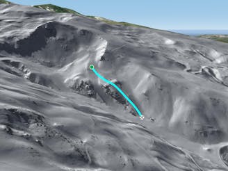
Easily accessed line as chairlifts "Parador I and II" will bring you there, however remember even though the line is alongside a red slope, this area can be technical due to the low altitude, as lack of snow is often present here. The line is steep as well as we are passing on top of a little river, where mistakes could be serious. Also the line is located between 2 pistes which makes higher the risk of collisions in case of loss of control. Remember this area is close the piste and artificial snow can come into the line meaning you could run into a mixture of snow types. The line will join red slope "Águila" bringing you back to the bottom of the ski resort.
Severe
Steep skiing at 38-45 degrees. This requires very good technique and the risk of falling has serious consequences.

As well as the slope itself, there are some obstacles (such as rock outcrops) which could aggravate injury.

Close to help in case of emergency.
222 m away
Rocky line right above the village.
Extreme Freeride Skiing
533 m away

Short cut lines between slopes.
Difficult Freeride Skiing
677 m away

Shortcut between slopes with rocks as main hazards.
Moderate Freeride Skiing
716 m away

A hiking line where few turns can be done into a wild area.
Severe Freeride Skiing
970 m away

A quick line which is easy to reach from the blue slopes and not too steep.
Difficult Freeride Skiing
1.2 km away

Easily accessed line close the piste.
Difficult Freeride Skiing
1.3 km away
A shortcut between black slopes on an ridge for experienced and skilled skiers.
Difficult Freeride Skiing
1.6 km away

A steep and short line between 2 black slopes below a ridge.
Severe Freeride Skiing
1.6 km away

Great total freeriding line between cliffs, steepness, rocks and often some good snow for only experts.
Extreme Freeride Skiing
1.6 km away

Different approach to the stadium line, but also steep.
Severe Freeride Skiing