1.1 km away
The Dossau snowdrift

A good place to learn how to jump on natural objects
Difficult Freeride Skiing
- Distance
- 1.2 km
- Ascent
- 5 m
- Descent
- 304 m
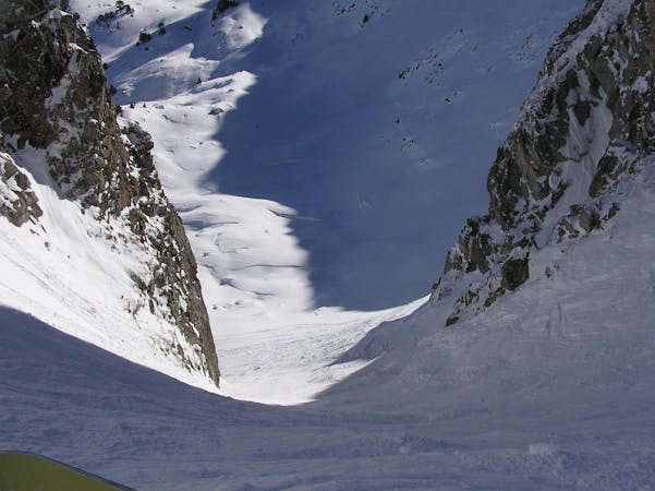
An open couloir
Freeride Skiing Severe

At the top of TS Dossau, take the TCD Dossau and take the blue run Colhet de Marimanha until you reach a natural mountain pass. Take off your skis and walk up the ridge in front of you, it is an open ridge that is easy to walk along. After 300 metres it gets narrower and flatter. The run starts halfway between the shoulder and the summit. The entrance sometimes has a cornice, so it is better to go in sideways and get onto the run a little bit before. The couloir is wide and steep at the top and becomes narrow in the middle section, after this narrow passage it gets wider and takes you back onto the piste. It is a short and fast run, people don't tend to do it because it takes a while to get there, but if you spend a few hours enjoying the Dossau area, it is a really good spot to go to.
Severe
Steep skiing at 38-45 degrees. This requires very good technique and the risk of falling has serious consequences.

As well as the slope itself, there are some obstacles (such as rock outcrops) which could aggravate injury.
Away from help but easily accessed.
1.1 km away
A good place to learn how to jump on natural objects
Difficult Freeride Skiing
1.2 km away

One of the best tree runs in Baqueira
Severe Freeride Skiing
1.2 km away
An area with trees and a lot of possibilities
Difficult Freeride Skiing
2.9 km away

Great fun natural jumps
Moderate Freeride Skiing
3.1 km away

An easy, aesthetic steep area with great lines, especially after snowfall.
Difficult Freeride Skiing
3.1 km away

Easy free ride to practise skiing in deep powder
Moderate Freeride Skiing
4.7 km away

A run for the adrenalin junkies
Severe Freeride Skiing
4.8 km away
One of the classic Baqueira off piste runs for experienced skiers.
Severe Freeride Skiing
5 km away

A tree run between creeks and boulders.
Moderate Freeride Skiing
5 km away

A beautiful, steep run between the pistes
Difficult Freeride Skiing
10 routes · Freeride Skiing