20 m away
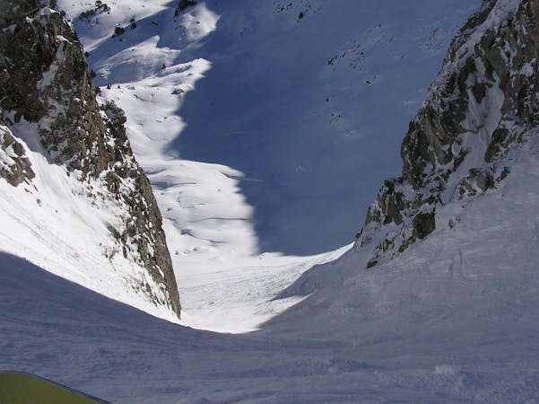
Ticolet

One of the best tree runs in Baqueira
Severe Freeride Skiing
- Distance
- 1.6 km
- Ascent
- 0 m
- Descent
- 477 m
An area with trees and a lot of possibilities
Freeride Skiing Difficult

From the top of the TS Dossau lift, follow the red Ticket piste and at the sharp turn on the left of the slope, turn right. You are going to be on top of a ridge that goes west, follow this ridge until you pass a steeper section, after 300m from the start and from there turn left. You can choose different options, if you go a little bit further along you will be able to play in a tree terrain where there is enough space to enjoy the powder. If you turn left a little beforehand, you will be able to play in a pretty steep section, enjoying the adrenaline of the steep open space, though this area can be avalanche prone, so check the avalanche risk beforehand. Both runs end up at the creek, which has big boulders. Here you will have to slow down and look for the best way to follow the creek that weaves left and right. The forest that surrounds the creek becomes thicker as you ski down. After the second turn of the creek, the forest becomes wider and you can see the really well marked cat track. Even though it can be laborious, generally there are some skiers' tracks who make this last part easier. Once at the end of the cat track, you will have to go left and walk for 1.5km to get back to the ski resort, following this path where you will see dog sleds, skidoos and other snow sports. There are some skidoo companies that if you give a call, they may pick you up for a reasonable price.
Difficult
Serious gradient of 30-38 degrees where a real risk of slipping exists.

As well as the slope itself, there are some obstacles (such as rock outcrops) which could aggravate injury.

In the high mountains or remote conditions, all individuals must be completely autonomous in every situation.
20 m away
One of the best tree runs in Baqueira
Severe Freeride Skiing
225 m away

A good place to learn how to jump on natural objects
Difficult Freeride Skiing
1.2 km away

An open couloir
Severe Freeride Skiing
2.9 km away

Great fun natural jumps
Moderate Freeride Skiing
3.2 km away

Easy free ride to practise skiing in deep powder
Moderate Freeride Skiing
3.4 km away

An easy, aesthetic steep area with great lines, especially after snowfall.
Difficult Freeride Skiing
4.5 km away

Open field
Moderate Freeride Skiing
4.6 km away

Great first contact with deep snow
Moderate Freeride Skiing
4.6 km away

Cliffs and untracked snow.
Severe Freeride Skiing
4.6 km away

Open snow field with easy access, as well as a nice rock jump.
Difficult Freeride Skiing
10 routes · Freeride Skiing