9.1 km away
Daube and Oberberghorn
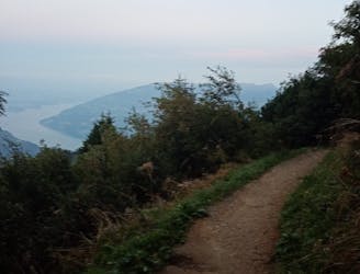
A contender for the most scenic hike in Switzerland!
Difficult Hiking
- Distance
- 3.7 km
- Ascent
- 222 m
- Descent
- 223 m
Hard path to go to the top but the view worth it. Amazing view of Mountains, Lake Thun and Lake Brienz at the top!
Hiking Difficult

Amazing view of the mountains, lake Thun and lake Brienz at the top. The path on the ridge is very beautiful but you must not have the dizziness to appreciate it. If you have still energy and time you can walk down from Harder Kulm to Interlaken if not you can take the funicular to go down. Estimated time without stop : 6h

Difficult
Hiking trails where obstacles such as rocks or roots are prevalent. Some obstacles can require care to step over or around. At times, the trail can be worn and eroded. The grade of the trail is generally quite steep, and can often lead to strenuous hiking.

Some trail sections have exposed ledges or steep ascents/descents where falling could cause serious injury.
Little chance of being seen or helped in case of an accident.
9.1 km away
A contender for the most scenic hike in Switzerland!
Difficult Hiking