4.1 km away
Urner Alps Traverse: Sustli Hut to Engleberg
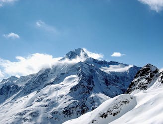
A great ski summit (Grassen, 2946m) followed by an 1800m N facing descent.
Difficult Ski Touring
- Distance
- 8.4 km
- Ascent
- 762 m
- Descent
- 1.9 km
Long and (moderately) technical skimountaineering tour
Ski Touring Severe

This is a very conditions dependent tour but hit it right and it's one of the best days out in the Alps!
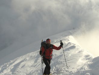
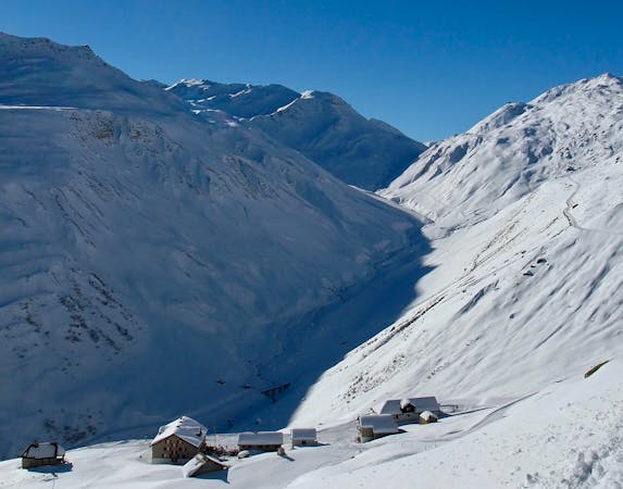
Park in Farnigen, or stay on the main road and park just above the village (road to the pass is blocked shortly after the turning to the village). Cross the river by the bridge just after the village and ascend 1000m of steep, avalanche prone terrain. It catches the sun early so if later in the season you will want to be (very) early - Although when we skied it in a cold snap in April it was still frozen hard.
As you climb, things begin to mellow until you reach the glacier. With a good track it would not be usual to rope up. As you approach the col there are two options (i) climb the rocky ridge. This can be semi technical with rock to grade III. A rope would be well advised. (ii) you can boot up a 45 deg couloir, which leads to a moderately exposed ridge and easily to the summit. Axe and crampons mandatory. Most people return by the same route - indeed, we had to put in a track to cross to the ridge.
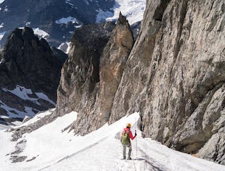
Depending on conditions, descending may not be trivial. We initially tried to move left from the crest. over a windlip - but found sugar snow lying on slabby rock, so opted for a slightly steeper climb down the ridge proper. the tricky section is only about 4m - but a fall would have bad consequences, so we roped up. The second can protect the first with a bucket belay - but there are few options for a secure belay to bring the second down. Its probably only Scottish I/II.
Having descended 20m, you can put on skis and descend and then travers on the W side, heading for the obvious col.
From the col you have a c.200m 45 (plus?) deg ski. It felt every bit 4.3. Don't forget there is a bergschrund at the bottom which should easily be crossed skiers rights. After the schrund enjoy easy turns, before traversing to the entrance of the Griessenstock N couloir (you'll need to step up about 10m to enter).
You now have a 500m 40 deg descent. Enjoy! There aren't many exit options as you get to the valley floor, so take care. Then head for the road and ski back to your car for beers and medals.
When we skied it in mid April we had 1500m of semi wind affected powder - bliss!
Severe
Steep skiing at 38-45 degrees. This requires very good technique and the risk of falling has serious consequences.

In case of a fall, death is highly likely.

Away from help but easily accessed.
4.1 km away
A great ski summit (Grassen, 2946m) followed by an 1800m N facing descent.
Difficult Ski Touring
7 km away
The traverse of the well named Füffingerstock and a long descent, before a short climb to the Sustli Hut.
Difficult Ski Touring
9.3 km away
A magnificent long glacial descent, with an optional high summit, the Sustenhorn (3502m).
Difficult Ski Touring
5 routes · Ski Touring