11 m away
Cubore
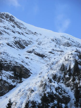
Great pitch that looks intimidating from above but offers a huge variety of lines that you can ride again and again.
Difficult Freeride Skiing
- Distance
- 1.1 km
- Ascent
- 5 m
- Descent
- 278 m
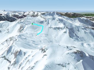
Easily accessed line but really steep.
Freeride Skiing Extreme

At the top of "Cuboré Montriand" chairlift go straight into the gully in front of you. The line is really steep at the entrance but lowr down the line can feel like a piste. However there is a streambed in the middle of the line and this can be a danger if there is low snow cover. The line gets a lot of early sun so make sure there's enough snow at the base before heading in. Avalanche risk is pretty important into the highest section due to the steepness. It finishes on the blue piste "Ripaille Bleu (skiers right of lifts)" which leads back to Champéry ski area.
Extreme
Extreme skiing terrain above 45 degrees. These routes are reserved for experienced experts.

As well as the slope itself, there are some obstacles (such as rock outcrops) which could aggravate injury.

Little chance of being seen or helped in case of an accident.
11 m away
Great pitch that looks intimidating from above but offers a huge variety of lines that you can ride again and again.
Difficult Freeride Skiing
22 m away

Challenging line for experienced backcountry skiers with airy and exposed ascent.
Severe Freeride Skiing
536 m away

A variety of lines for experienced skiers with airy, exposed ascent.
Difficult Freeride Skiing
537 m away

Classic off-piste route for experienced skiers with short but exposed hike.
Difficult Freeride Skiing
624 m away

Very lappable area of small drops and rollovers.
Moderate Freeride Skiing
1.5 km away

Quick shortcut re-joining the same slope, with a technical entrance.
Severe Freeride Skiing
1.6 km away

Short cut line under "Mossettes-Suisse" chairlift with some very steep ground.
Extreme Freeride Skiing
1.8 km away

A legendary couloir known to be popular with the local ski patrol, for expert skiers only.
Severe Freeride Skiing
1.8 km away

Short cut line close the slopes
Moderate Freeride Skiing
2 km away

The Freeride World Qualifier face in Morgins.
Difficult Freeride Skiing

18 routes · Freeride Skiing
9 routes · Freeride Skiing · Ski Touring