1 m away
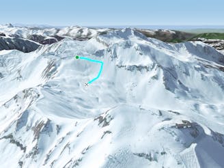
Pointe de Vorlaz: North Face

A variety of lines for experienced skiers with airy, exposed ascent.
Difficult Freeride Skiing
- Distance
- 1.3 km
- Ascent
- 0 m
- Descent
- 537 m
Classic off-piste route for experienced skiers with short but exposed hike.
Freeride Skiing Difficult

To reach the summit of the Vorlaz you must first get to the top of the Cubore chairlift (the "up and over chair") via the Fornet bowl or by taking the Mossettes chairlift and skiing round to meet the Cubore at the other side. Once at the top follow the traverse line underneath the Vorlaz on the Fornet side for about 100m. You will then need to make a half hour hike directly up to the ridge up a very steep pitch. In winter there is often an obvious boot pack to follow but beware that this is very steep and you will need to attach skis to your rucksack for the climb. This south facing slope can become very warm in spring time and the snow can quickly become rotten so be sure to get here early.
Once you reach the ridge follow the boot pack along to the summit. It can feel very exposed in sections with the sides dropping away very steeply, it is important to feel confident about making such an ascent before you begin because once you are on the ridge there is no turning back.
The view at the summit extends in all directions and gives you a great impression of the whole Portes du Soleil. There are so many different lines to choose from. To join the easiest route you must ski 50m along the top before diving down to your right into an enormous valley. For those seeking a steeper descent, stay high as you cut right and hug the cliff band before descending into the valley below. The valley ends at the Brocheaux chairlift.
This is not a particularly steep and technical route but has a distinct backcountry feel despite being sandwiched between two busy areas of the resort.
Difficult
Serious gradient of 30-38 degrees where a real risk of slipping exists.

As well as the slope itself, there are some obstacles (such as rock outcrops) which could aggravate injury.
Away from help but easily accessed.
1 m away
A variety of lines for experienced skiers with airy, exposed ascent.
Difficult Freeride Skiing
521 m away

Challenging line for experienced backcountry skiers with airy and exposed ascent.
Severe Freeride Skiing
527 m away
Great pitch that looks intimidating from above but offers a huge variety of lines that you can ride again and again.
Difficult Freeride Skiing
537 m away

Easily accessed line but really steep.
Extreme Freeride Skiing
924 m away

Very lappable area of small drops and rollovers.
Moderate Freeride Skiing
1.4 km away

Short cut line close the slopes
Moderate Freeride Skiing
1.5 km away

Quick shortcut re-joining the same slope, with a technical entrance.
Severe Freeride Skiing
1.6 km away

Short cut line under "Mossettes-Suisse" chairlift with some very steep ground.
Extreme Freeride Skiing
1.9 km away

A legendary couloir known to be popular with the local ski patrol, for expert skiers only.
Severe Freeride Skiing
2 km away

A ice long line giving some steepness and some tree skiing which requires good skills.
Severe Freeride Skiing

18 routes · Freeride Skiing
9 routes · Freeride Skiing · Ski Touring