169 m away
Top col de bassachaux line 2

A long line with a mix of steepness, forest and untracked areas.
Extreme Freeride Skiing
- Distance
- 413 m
- Ascent
- 0 m
- Descent
- 163 m
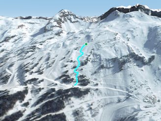
Steep shortcut line between a green slope.
Freeride Skiing Severe

Not the longest line of the resort but a good line mixing steepness, avalanches risk is present as the area is steep and we going into a steep entrance, nothing really worry unless some steepness into this part. Entrance can be taken as cliff by the green slope with some speed if needed, however this is totally optional. Our line will be between trees what make easy to find this one and the navigation, as we are below 1600 meters low snow covers can make it dangerous. Good checked of the winter snow condition is needed. Small trees can be found into the middle of the line, in case of weak snow cover. Remember will finish into a green slope what mean good control needed to void any collisions with some novice skiers. From there you can get back access to the "Plaine Dranse" or "Pierre longue" chairlifts.
Severe
Steep skiing at 38-45 degrees. This requires very good technique and the risk of falling has serious consequences.

As well as the slope itself, there are some obstacles (such as rock outcrops) which could aggravate injury.

Close to help in case of emergency.
169 m away
A long line with a mix of steepness, forest and untracked areas.
Extreme Freeride Skiing
456 m away

A nice shortcut (which is often tracked) with mellow skiing. A nice area to go to in case of low visibility during powder days.
Difficult Freeride Skiing
577 m away

Another shortcut line bringing you back to the "Cornebois" chairlift.
Moderate Freeride Skiing
581 m away

Another nice shortcut in an easy part of the mountain giving some nice tree skiing.
Moderate Freeride Skiing
585 m away

Easy shortcut line
Moderate Freeride Skiing
588 m away

An often tracked forest run which leads to the "Cornebois" chairlift.
Moderate Freeride Skiing
610 m away
A nice line starting easy but requiring good skills later on.
Severe Freeride Skiing
627 m away

A 300 meter tree line between small and bigger trees, including a river in the middle. Good skiers only!
Severe Freeride Skiing
649 m away

A tough line where good skills are needed.
Severe Freeride Skiing
786 m away

An under-chairlift line with some steepness and trees.
Extreme Freeride Skiing