301 m away
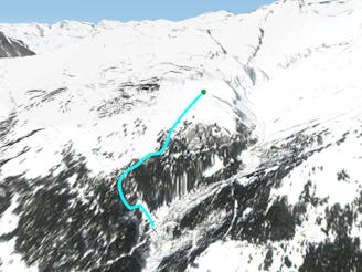
Petite Faverges

A classic off piste line, with easy access and no skinning needed.
Difficult Freeride Skiing
- Distance
- 3.2 km
- Ascent
- 32 m
- Descent
- 795 m
Classiest run in Aminona sector
Freeride Skiing Difficult

From TSA lift you go above the restaurant going towards the mountain you see in front, the Petit Bonvin. Here you need to walk, not as far as the rocks, but around 100 m up. Then you can do a diagonal to finish next to the rocks of Petit Bonvin. There you will find a couloir of about 40 meters, which leads to an open run. You have different options here. The best one is all the way down and when you see some cliffs on your left you will go above them. After this you will cross a path and go to an open forest to finish in an open area where you will see some chalets. Here you join the Faverges off piste line, until you get to Aprili slope. Follow the slope all the way down to the bus stop at the base. There is a bus every 15 min which take you to Barzettes lift.
Difficult
Serious gradient of 30-38 degrees where a real risk of slipping exists.

As well as the slope itself, there are some obstacles (such as rock outcrops) which could aggravate injury.

Little chance of being seen or helped in case of an accident.
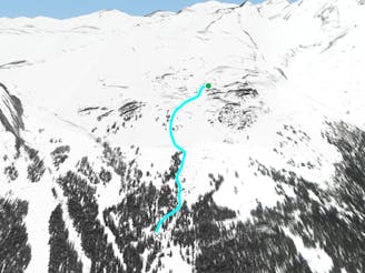
301 m away
A classic off piste line, with easy access and no skinning needed.
Difficult Freeride Skiing
999 m away

Dream run in the forest
Moderate Freeride Skiing
2 km away
Forest- perfect for foggy days
Moderate Freeride Skiing
2.4 km away

Wide classic line coming from the glacier
Difficult Freeride Skiing
2.6 km away
Easy open run
Easy Freeride Skiing
2.6 km away

Long easy journey around one of the most beautiful areas in Crans-Montana
Moderate Freeride Skiing
3 km away

Open easy run where you can ski fast and wide
Moderate Freeride Skiing
3.9 km away
The most classic steep freeride run around Crans-Montana
Difficult Freeride Skiing
4.1 km away

The first run of the day
Easy Freeride Skiing
5.1 km away

One of the classic lines with really easy access.
Moderate Freeride Skiing
11 routes · Freeride Skiing