495 m away
Faverges

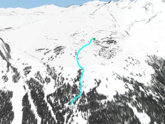
Long easy journey around one of the most beautiful areas in Crans-Montana
Moderate Freeride Skiing
- Distance
- 4.1 km
- Ascent
- 70 m
- Descent
- 941 m
Wide classic line coming from the glacier
Freeride Skiing Difficult

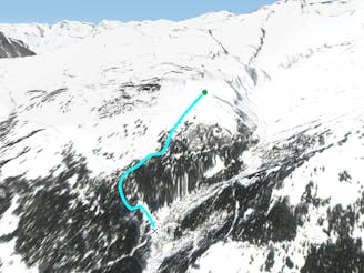
When you go down the Kandahar slope, after the first flat part you get to a path to go to a steeper part. This gets you into the valley to the way down to the Cabane des Bois. Before this valley starts you can see Mont Tubang on your left. To access to this run you need to traverse all the way above this mountain. You keep on going until you find cliffs just in front of you. Here you just need to go down diagonally to the right. There are a few rocks to avoid in the middle, and you need to be careful if you follow straight down instead of going to the right because there are cliffs at the beginning.
Difficult
Serious gradient of 30-38 degrees where a real risk of slipping exists.

As well as the slope itself, there are some obstacles (such as rock outcrops) which could aggravate injury.
Away from help but easily accessed.
495 m away
Long easy journey around one of the most beautiful areas in Crans-Montana
Moderate Freeride Skiing
2.1 km away

A classic off piste line, with easy access and no skinning needed.
Difficult Freeride Skiing
2.3 km away

Open easy run where you can ski fast and wide
Moderate Freeride Skiing
2.4 km away

Classiest run in Aminona sector
Difficult Freeride Skiing
2.6 km away

Dream run in the forest
Moderate Freeride Skiing
2.6 km away
Forest- perfect for foggy days
Moderate Freeride Skiing
2.8 km away
Easy open run
Easy Freeride Skiing
3.9 km away
The most classic steep freeride run around Crans-Montana
Difficult Freeride Skiing
4.2 km away

The first run of the day
Easy Freeride Skiing
4.8 km away

One of the classic lines with really easy access.
Moderate Freeride Skiing
11 routes · Freeride Skiing