5.3 km away
Monte Rosa Haute Route: Neue Monte Rosa Hut to Zermatt via Dufourspitze Monte Rosa
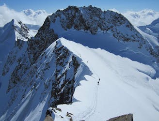
Day 5: A huge skin to a high col and optional climb up Europe's 2nd highest peak
Severe Ski Touring
- Distance
- 21 km
- Ascent
- 1.6 km
- Descent
- 2.8 km
A nice couloir often in good conditions
Also in Verbano-Cusio-Ossola, Italy
Ski Touring Severe

This couloir can be easily seen from Macugnaga. Starting from the Belvedere chairlift top station, cross the glacier moraine in the direction of the couloir, it's a wide couloir which is not extremely steep and it provides an excellent ski tour when in condition. 30 mt rope required just in case of hard snow to climb. The peak and descent provide wonderful views over the East face of Monte Rosa. Be careful as due to the aspect, the sun can warm up and destabilize the snow causing rocks and ice to come loose.
Severe
Steep skiing at 38-45 degrees. This requires very good technique and the risk of falling has serious consequences.

As well as the slope itself, there are some obstacles (such as rock outcrops) which could aggravate injury.

In the high mountains or remote conditions, all individuals must be completely autonomous in every situation.
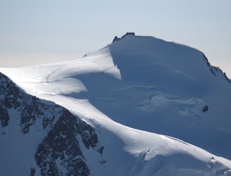
5.3 km away
Day 5: A huge skin to a high col and optional climb up Europe's 2nd highest peak
Severe Ski Touring
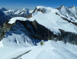
8.4 km away
Day 4: Margherita Hut and the Grenz Glacier, beginning at Gnifettti Hut and ending at Neue Monte Rosa Hut
Difficult Ski Touring
9.4 km away
One of the easier 4000m peaks in the Alps
Moderate Ski Touring

5 routes · Freeride Skiing · Ski Touring

5 routes · Ski Touring

50 routes · Freeride Skiing · Ski Touring

6 routes · Ski Touring
16 routes · Ski Touring