5.2 km away
High Street from Haweswater
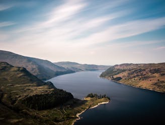
People have walked High Street for thousands of years, and they'll probably be doing so for generations to come.
Difficult Hiking
- Distance
- 9.8 km
- Ascent
- 638 m
- Descent
- 632 m
Sadgill - Grey Crag - Tarn Crag - Branstree - Selside Pike - Gatescarth Pass - Sadgill
Hiking Moderate

This is a popular hiking route which is generally considered to be moderate. It's remote, it features low exposure and is typically done all year round. From a low point of 192 m to the maximum altitude of 710 m, the route covers 15 km, 894 vertical metres of ascent and 894 vertical metres of descent.
Sadgill - Grey Crag - Tarn Crag - Branstree - Selside Pike - Gatescarth Pass - Sadgill
Moderate
Hiking along trails with some uneven terrain and small hills. Small rocks and roots may be present.

The path is on completely flat land and potential injury is limited to falling over.

Away from help but easily accessed.
5.2 km away
People have walked High Street for thousands of years, and they'll probably be doing so for generations to come.
Difficult Hiking