76 m away
Ciste Gully

One of Cairngorm's longest descents close to the lift system
Difficult Freeride Skiing
- Distance
- 3 km
- Ascent
- 12 m
- Descent
- 561 m
A useful vantage point before trying the more serious Coire Cas headwall
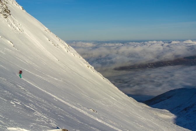
Freeride Skiing Moderate

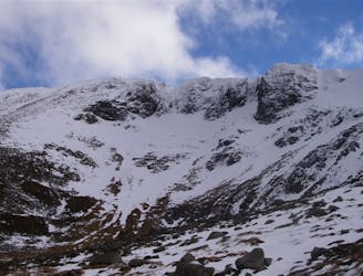
The Coronation Wall is a wide, open face, accessed from the Ptarmigan top station, which finishes in Coire Cas. The route has a lengthy traverse to access the main face, but it is a great asset for assessing conditions around Coire Cas if you're thinking of tackling the more serious Coire Cas headwall.
Start by traversing in a south-westerly direction from the Ptarmigan building. It's important that you keep as much height as possible here, to ensure you get the best descent on the Coronation Wall itself.
As you traverse around the mountain, the Coire Cas headwall will appear ahead, and the “Traverse” green-grade marked run will be running roughly parallel to your tracks. Once you’ve reached this point, you can choose when to start the proper descent, which will end on the green run below. Either take a zig-zag route down towards the Coire Cas t-bar or, if you’re itching to get going, you can simply shred straight down to the run below.
It’s important to be aware of the avalanche risk in this area. Cairngorm Mountain generally display flags near the Ptarmigan station, warning of any potential avalanche danger.
Despite the combination of a long traverse with a relatively short descent, the Coronation Wall is a great way to get up close to the steeper Coire Cas headwall, to scope out any potential dangers there.
Moderate
Slopes become slightly steeper at around 25-30 degrees.

Exposure is limited to that of the slope itself. Getting hurt is still likely if the slope is steep and/or the snow is hard.

Away from help but easily accessed.
76 m away
One of Cairngorm's longest descents close to the lift system
Difficult Freeride Skiing
351 m away

A snow sure descent with stunning scenery
Difficult Freeride Skiing
361 m away

A short, gentle introduction to off-piste skiing
Easy Freeride Skiing
412 m away

A classic descent at Cairngorm for advanced riders
Difficult Freeride Skiing
678 m away

A playful off-piste route above Cairngorm's famous White Lady
Moderate Freeride Skiing
3.6 km away
One of the most skied patches of snow in Scotland.
Moderate Freeride Skiing
5 routes · Freeride Skiing
7 routes · Freeride Skiing · Ski Touring