205 m away
West Highland Way
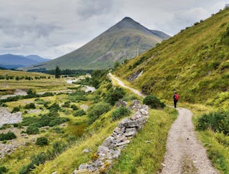
A wonderful journey through the rugged and wild mountains of the Scottish Highlands.
Difficult Hiking
- Distance
- 153 km
- Ascent
- 3.3 km
- Descent
- 3.3 km
The beginning of West Highland Way, heading northward from Milngavie to the first of many natural lochs along the trail, among hillier and muddier terrain.
Also in East Dunbartonshire, United Kingdom
Hiking Easy

This is a popular hiking route which is generally considered to be easy. It's an unknown remoteness, it features unknown exposure and is typically done in an unknown time of year. From a low point of 19 m to the maximum altitude of 137 m, the route covers 19 km, 288 vertical metres of ascent and 280 vertical metres of descent.
Easy
Walking along a well-kept trail that’s mostly flat. No obstacles are present.
205 m away
A wonderful journey through the rugged and wild mountains of the Scottish Highlands.
Difficult Hiking