6.6 km away
Root Glacier Trail
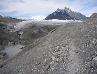
One of Alaska's most incredible easy-to-access hikes!
Moderate Hiking
- Distance
- 15 km
- Ascent
- 625 m
- Descent
- 625 m
A mellow hike leading to beautiful glacier views!
Hiking Easy

If you're looking for a mellow hike in the utterly massive Wrangell-St. Elias National Park that still lets you gain stunning glacier views, the West Kennecott Glacier Trail is just the ticket!
The trail begins from an easily-accessible trailhead and skirts around a residence by climbing over a small hill. After the short up and over, the route rejoins an old road-turned-trail leading to the field of glacial debris.
This mellow two-mile round-trip hike may be one of the easiest but most rewarding hikes in the national park! As you reach the river running down from the glacier, you'll be greeted by stunning mountain views, views of the glacier in the distance, and an incredible feeling of serenity as if you're deep in the wilderness, even though you're just a mile off the road.
Easy
Walking along a well-kept trail that’s mostly flat. No obstacles are present.

The path is on completely flat land and potential injury is limited to falling over.

Away from help but easily accessed.
6.6 km away
One of Alaska's most incredible easy-to-access hikes!
Moderate Hiking
6.7 km away
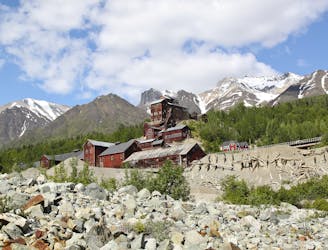
Climb to a historic mine located thousands of vertical feet above the town of Kennecott.
Difficult Hiking

25 routes · Alpine Climbing · Hiking

5 routes · Hiking

63 routes · Alpine Climbing · Hiking