
8 routes · Hiking
The Ozark Highlands Trail is an epic 164-mile long hiking trail across northern Arkansas in the Ozark Mountains.
Hiking Moderate

Construction of the Ozark Highlands Trail (OHT) began in 1977, funded by the U.S. Forest Service. When funding ran out in 1981, with only a third of the planned 164-mile trail built, Tim Ernst stepped up to establish the Ozark Highlands Trail Association (OHTA) to complete construction using only volunteer labor.
The OHTA, created for the sole purpose to "Build, Maintain, and Enjoy the OHT," continues to take care of the trail to this day. OHTA is a non-profit organization with no outside funding, relying solely on membership fees and donations to stay afloat. If you would like to help support this effort, go to OzarkHighlandsTrail.com. Membership starts at just $20. The Ozark Highlands Trail begins at Lake Fort Smith State Park. This is a beautiful, “totally modern” state park, complete with a swimming pool, camping, park headquarters, visitor center, cabins, and group lodging. There is a designated parking area for hikers located at the start of the trail. If you plan to be out overnight, please notify the staff at the visitor center.
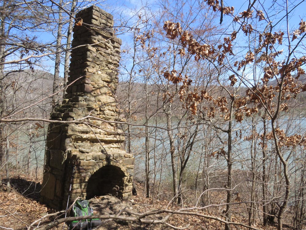
The OHT follows the shore of Lake Fort Smith for the first three miles of the hike, affording open views across the lake. During this stretch, you will pass the chimneys of two separate homesites. You will also view a spring seeping out of the hillside which supplied water for one of the settlements.
After about three miles the trail crosses Frog Bayou Creek. This is normally a wet crossing and at times could be potentially dangerous, so monitor recent rainfall before beginning. If you cannot see the bottom of the creek, do not cross.
Section 1 is a good example of the terrain hikers will experience on most of the OHT, with constant rolling hills, crystal clear drainages, hilltop views, and Ozark backwoods. Plus, you will discover a wide selection of potential campsites to pitch your home for the night, because you are not restricted to designated campsites.
Near mile 10 the trail crosses Hurricane Creek. This will provide your last reliable water source until reaching the end of Section 1.
At mile 16.6 the OHT intersects with a spur trail (marked with blue blazes, while the OHT uses white blazes) that is part of a 14.4-mile loop trail to Shores Lake. The OHT continues straight.
The OHT encounters another intersection at mile 17.4. A 0.3-mile spur trail to the left routes hikers to the White Rock Recreation Area. That area includes cabins, residential houses, and campgrounds that were built in the 1930s by the Civilian Conservation Corps. The area also includes one of the most spectacular bluff views on the trail. If you time your hike right, you will be treated to an open, unobstructed view of the setting sun over a distant mountain ridge.
Moderate
Hiking along trails with some uneven terrain and small hills. Small rocks and roots may be present.

The path is on completely flat land and potential injury is limited to falling over.

Away from help but easily accessed.
8 routes · Hiking