7.1 km away
Far Corner

The easiest couloir in the sidecountry of Kirkwood but also a bit far
Difficult Freeride Skiing
- Distance
- 886 m
- Ascent
- 0 m
- Descent
- 351 m
A very enjoyable bowl that takes a bit of hiking to get to
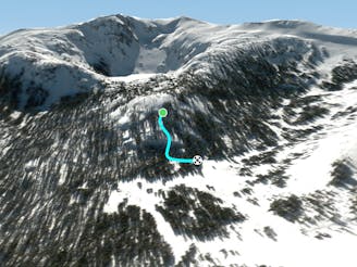
Freeride Skiing Moderate

This is a popular freeride skiing route which is generally considered to be moderate. It's very remote, it features low exposure (e1) and is typically done between December and April. From a low point of 2.4 km to the maximum altitude of 2.6 km, the route covers 571 m, 0 vertical metres of ascent and 203 vertical metres of descent.
Jake's can be accessed by hiking up The Wrist to the top of The Fingers Chutes. Instead of skiing skiers' left towards The Fingers, you'll ski skiers' right into a fun bowl with a few trees scattered here and there.
Moderate
Slopes become slightly steeper at around 25-30 degrees.

Exposure is limited to that of the slope itself. Getting hurt is still likely if the slope is steep and/or the snow is hard.

Little chance of being seen or helped in case of an accident.
7.1 km away
The easiest couloir in the sidecountry of Kirkwood but also a bit far
Difficult Freeride Skiing
7.1 km away

Classic North Facing line of Peak 9795
Extreme Freeride Skiing
7.1 km away

A classic western facing Y couloir from Peak 9795
Severe Freeride Skiing
7.2 km away

Adventurous classic narrow chute on the way to California Chutes
Difficult Freeride Skiing
7.3 km away

Steep and short northwest facing slope that leads into Sally Alley
Difficult Freeride Skiing
7.5 km away

An low consequence and lower angle zone that will give a good perspective of the surrounding area
Moderate Freeride Skiing
7.8 km away
Extremely fun and technical area with small to medium cliffs near the bottom of Chair 4
Difficult Freeride Skiing
7.8 km away

East facing chutes down to Emigrant Lake
Difficult Freeride Skiing
8 km away

Very steep couloir with a narrow crux at the end before funneling down to Emigrant Lake
Severe Freeride Skiing
8 km away

An extremely steep and exposed line and riddled with large granite obstacles.
Severe Freeride Skiing

7 routes · Freeride Skiing