7.1 km away
Far Corner

The easiest couloir in the sidecountry of Kirkwood but also a bit far
Difficult Freeride Skiing
- Distance
- 886 m
- Ascent
- 0 m
- Descent
- 351 m
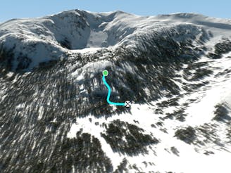
Trio of difficult chutes
Freeride Skiing Difficult

Proceed down the ridge till you must hike up to a small mound that signify the start of The Lost Lake Chutes. Skiers' left is the easiest while skiers' right are the two tougher chutes. There will most likely be a mild cornice. Once you drop these chutes, keep going skiers' right towards the second half of these chutes which consists of moderate straightlines and cliff jumps! Experts only!
Difficult
Serious gradient of 30-38 degrees where a real risk of slipping exists.

As well as the slope itself, there are some obstacles (such as rock outcrops) which could aggravate injury.

Little chance of being seen or helped in case of an accident.
7.1 km away
The easiest couloir in the sidecountry of Kirkwood but also a bit far
Difficult Freeride Skiing
7.1 km away

Classic North Facing line of Peak 9795
Extreme Freeride Skiing
7.1 km away

A classic western facing Y couloir from Peak 9795
Severe Freeride Skiing
7.1 km away

Adventurous classic narrow chute on the way to California Chutes
Difficult Freeride Skiing
7.2 km away

Steep and short northwest facing slope that leads into Sally Alley
Difficult Freeride Skiing
7.4 km away

An low consequence and lower angle zone that will give a good perspective of the surrounding area
Moderate Freeride Skiing
8 km away

East facing chutes down to Emigrant Lake
Difficult Freeride Skiing
8 km away

Very steep couloir with a narrow crux at the end before funneling down to Emigrant Lake
Severe Freeride Skiing
8 km away

An extremely steep and exposed line and riddled with large granite obstacles.
Severe Freeride Skiing
8 km away
Extremely fun and technical area with small to medium cliffs near the bottom of Chair 4
Difficult Freeride Skiing

7 routes · Freeride Skiing