6.1 km away
Far Corner

The easiest couloir in the sidecountry of Kirkwood but also a bit far
Difficult Freeride Skiing
- Distance
- 886 m
- Ascent
- 0 m
- Descent
- 351 m
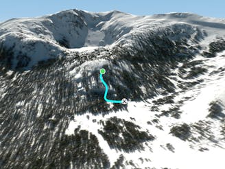
Last of these south facing bowls
Freeride Skiing Moderate

This is a popular freeride skiing route which is generally considered to be moderate. It's extremely remote, it features medium exposure (e2) and is typically done between January and April. From a low point of 2.4 km to the maximum altitude of 2.6 km, the route covers 1.1 km, 1 vertical metres of ascent and 207 vertical metres of descent.
Like its neighbors, Low Entry suffers from a southern aspect that really hurts snow conditions in this area when conditions aren't prime. It also offers the least vertical out of these bowls. The one advantage is that it's a bit tricky to reach so snow can stay fresher here.
Moderate
Slopes become slightly steeper at around 25-30 degrees.

As well as the slope itself, there are some obstacles (such as rock outcrops) which could aggravate injury.

In the high mountains or remote conditions, all individuals must be completely autonomous in every situation.
6.1 km away
The easiest couloir in the sidecountry of Kirkwood but also a bit far
Difficult Freeride Skiing
6.2 km away

Classic North Facing line of Peak 9795
Extreme Freeride Skiing
6.2 km away

A classic western facing Y couloir from Peak 9795
Severe Freeride Skiing
6.2 km away

Adventurous classic narrow chute on the way to California Chutes
Difficult Freeride Skiing
6.4 km away

Steep and short northwest facing slope that leads into Sally Alley
Difficult Freeride Skiing
6.4 km away
Extremely fun and technical area with small to medium cliffs near the bottom of Chair 4
Difficult Freeride Skiing
6.5 km away

An low consequence and lower angle zone that will give a good perspective of the surrounding area
Moderate Freeride Skiing
6.6 km away

East facing chutes down to Emigrant Lake
Difficult Freeride Skiing
6.9 km away

Very steep couloir with a narrow crux at the end before funneling down to Emigrant Lake
Severe Freeride Skiing
6.9 km away

An extremely steep and exposed line and riddled with large granite obstacles.
Severe Freeride Skiing

7 routes · Freeride Skiing