2.1 km away
Temple of Doom
Extremely fun and technical area with small to medium cliffs near the bottom of Chair 4
Difficult Freeride Skiing
- Distance
- 288 m
- Ascent
- 0 m
- Descent
- 77 m
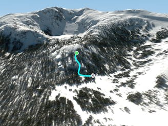
One of the more challenging lines in the Lakeside Gullies area
Freeride Skiing Moderate

No Man's Land is a really interesting line in the Lakeside Gullies area that essentially goes between two large rock walls. It's quite narrow and has a steep middle portion as compared to some of the some of the other runs in this area. The last part of run weaves through some very lightly gladed terrain that's super enjoyable! After this section, you'll filter onto Lower Black Butte Gully. This is very interesting and unique intermediate terrain that should be attempted by a solid intermediate backcountry skier!
Moderate
Slopes become slightly steeper at around 25-30 degrees.

Exposure is limited to that of the slope itself. Getting hurt is still likely if the slope is steep and/or the snow is hard.

Little chance of being seen or helped in case of an accident.
2.1 km away
Extremely fun and technical area with small to medium cliffs near the bottom of Chair 4
Difficult Freeride Skiing
2.5 km away

East facing chutes down to Emigrant Lake
Difficult Freeride Skiing
2.6 km away

A classic western facing Y couloir from Peak 9795
Severe Freeride Skiing
2.6 km away

Fairly steep run with small to medium cliffs scattered throughout in all directions
Difficult Freeride Skiing
2.6 km away

The easiest couloir in the sidecountry of Kirkwood but also a bit far
Difficult Freeride Skiing
2.6 km away

Classic North Facing line of Peak 9795
Extreme Freeride Skiing
2.7 km away

Adventurous classic narrow chute on the way to California Chutes
Difficult Freeride Skiing
2.8 km away

Steep and short northwest facing slope that leads into Sally Alley
Difficult Freeride Skiing
2.9 km away

An extremely steep and exposed line and riddled with large granite obstacles.
Severe Freeride Skiing
2.9 km away

Very steep couloir with a narrow crux at the end before funneling down to Emigrant Lake
Severe Freeride Skiing

7 routes · Freeride Skiing