7.9 km away
Pipeline

Classic North Facing line of Peak 9795
Extreme Freeride Skiing
- Distance
- 667 m
- Ascent
- 1 m
- Descent
- 357 m

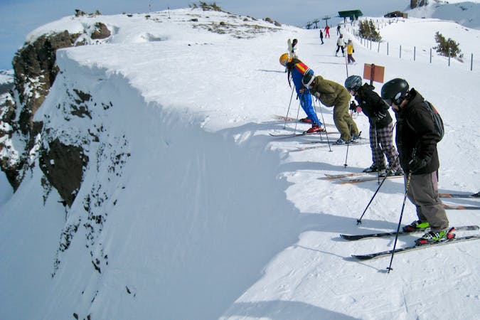
Crazy Face that usually requires mandatory air
Freeride Skiing Extreme

To get here, take the Lakeside Ridge and follow the trail around Lost Lake. This is the run directly after the rocky couloir and you must hike uphill a bit from the trail itself to get here. Almost bet on there being a decently sizable cornice entry into the zone. Depending on the snow conditions, there could be a goat path that doesn't require mandatory air but if you're considering that path, you probably shouldn't be attempting this run. This is extremely steep and has a ton of exposure! After dropping the cliff, things mellow out fairly quickly and there's little exposure past the initial drop. Just watch out for the cliffs towards the bottom on skiers' left.
Extreme
Extreme skiing terrain above 45 degrees. These routes are reserved for experienced experts.
7.9 km away

Classic North Facing line of Peak 9795
Extreme Freeride Skiing
7.9 km away

The easiest couloir in the sidecountry of Kirkwood but also a bit far
Difficult Freeride Skiing
7.9 km away

A classic western facing Y couloir from Peak 9795
Severe Freeride Skiing
7.9 km away

Adventurous classic narrow chute on the way to California Chutes
Difficult Freeride Skiing
8 km away

Steep and short northwest facing slope that leads into Sally Alley
Difficult Freeride Skiing
8.2 km away

An low consequence and lower angle zone that will give a good perspective of the surrounding area
Moderate Freeride Skiing
8.8 km away

Very steep couloir with a narrow crux at the end before funneling down to Emigrant Lake
Severe Freeride Skiing
8.8 km away

An extremely steep and exposed line and riddled with large granite obstacles.
Severe Freeride Skiing
8.8 km away

East facing chutes down to Emigrant Lake
Difficult Freeride Skiing
8.9 km away

Fun technical area that leads into some large cliffs above Emigrant Lake
Difficult Freeride Skiing

7 routes · Freeride Skiing