2.3 km away
Temple of Doom
Extremely fun and technical area with small to medium cliffs near the bottom of Chair 4
Difficult Freeride Skiing
- Distance
- 288 m
- Ascent
- 0 m
- Descent
- 77 m
Some really easy-to-access hike-to terrain that gets tougher the further you go
Freeride Skiing Severe

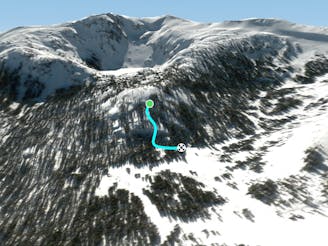
The Black Butte Chutes are a series of chutes accessed off the tiny peak "Black Butte". The lines here are extremely short, but are often overlooked as they're out of the way (both Round Top and Deadwood Peak loom in the distance). They usually hold some really nice snow. The lines get more and more extreme as you go further along the hike. The hike also gets more technical to reach those last 2 chutes with some scrambling required. Those last two lines generally don't hold snow well and are extremely technical and therefore seldom skied. The rest of the runs here are very enjoyable despite their shorter length and advanced - expert skiers will have a lot of fun with them. To get here, you can either hike directly from the Woods Lake Campground or ride down Round Top Peak's Highway and then hike at the right turn to get back to Woods Lake Campground. Once you finish riding your chosen line simply cross the open area in front of you (don't worry, that isn't a frozen lake, it's just a meadow!) and rejoin with Highway. These Chutes a great way to warm up for the steeps of Round Top and Deadwood Peak if you have the time!
Severe
Steep skiing at 38-45 degrees. This requires very good technique and the risk of falling has serious consequences.

As well as the slope itself, there are some obstacles (such as rock outcrops) which could aggravate injury.
Away from help but easily accessed.
2.3 km away
Extremely fun and technical area with small to medium cliffs near the bottom of Chair 4
Difficult Freeride Skiing
2.8 km away

Fairly steep run with small to medium cliffs scattered throughout in all directions
Difficult Freeride Skiing
2.8 km away

East facing chutes down to Emigrant Lake
Difficult Freeride Skiing
2.8 km away

A classic western facing Y couloir from Peak 9795
Severe Freeride Skiing
2.8 km away

The easiest couloir in the sidecountry of Kirkwood but also a bit far
Difficult Freeride Skiing
2.9 km away

Classic North Facing line of Peak 9795
Extreme Freeride Skiing
2.9 km away

Adventurous classic narrow chute on the way to California Chutes
Difficult Freeride Skiing
3.1 km away

Steep and short northwest facing slope that leads into Sally Alley
Difficult Freeride Skiing
3.1 km away

The upper section has a few small chutes and cliffs that lead into an open field and then into some trees but usually holds variable snow.
Difficult Freeride Skiing
3.2 km away

An extremely steep and exposed line and riddled with large granite obstacles.
Severe Freeride Skiing

7 routes · Freeride Skiing