7.4 km away
Cedar Creek Falls
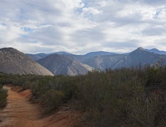
Descend into a river gorge with a crisp waterfall and swimming hole.
Difficult Hiking
- Distance
- 8.8 km
- Ascent
- 316 m
- Descent
- 316 m
Steep and exposed hike to a stack of three large waterfalls in a granite basin
Hiking Difficult

The Three Sisters are a trio of tiered waterfalls collectively measuring more than 100 feet in height, which flow through a remote canyon of Boulder Creek northeast of San Diego. The magic of cascading water in the desert lures more people than probably belong to this unforgiving environment. The hike to Three Sisters is very steep, quite rugged, and mostly on south slopes that bake in the sun. It has a history of serious injuries and evacuations, but can be done safely if you come prepared and remain careful. You need sturdy shoes with good grip, lots of water and snacks, and sun protection. Dogs are allowed on leash, but bringing your dog isn't recommended on this trail.
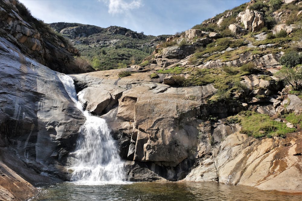
The final descent to the falls used to follow a precipitous, sandy, and rocky slope, but in 2018 the Forest Service constructed a more sensible trail that bypasses this section. It’s now safer with the new trail, but still, nothing to be taken lightly. Accidents continue to happen, mostly at the falls themselves and on the steep section when people ignore the new trail.
To safely enjoy the waterfalls, stay at the bottom. It’s possible to scramble on rock slabs to reach the upper tiers, but the granite is slick and dangerously steep, especially when the falls have a lot of water. In times of low flow, you can wade or swim in the pools between tiers, but with high flow it becomes impossible. The pool above the lowest tier and below the second is not too difficult to reach, but beyond there it gets much steeper. Attempt the climb only if you are experienced and have proper footwear. From below the falls, you can still enjoy the view, wade in the creek, and relax in sun or shade among the trees.
The falls flow reliably in winter and spring, so these cooler months are the best time to go, especially because the hike is less brutal. They can flow at other times, too, though, after heavy rains or in particularly wet years. The gorge is downstream of Cuyamaca Reservoir, so when the lake is full it may release water over the falls well into summer.
The mapped route takes the new trail, avoiding the steep scramble. The old trail remains open, so you’ll have to note the junction when you reach it and remember to keep going on the new trail, which stays high and traverses the hillside instead of going straight down.
Note: This hike does not require a special permit like Cedar Creek Falls, but does require a California Adventure Pass to park at the trailhead.
Sources: https://www.fs.usda.gov/detail/cleveland/news-events/?cid=FSEPRD538001 https://californiathroughmylens.com/three-sisters-falls/ https://www.world-of-waterfalls.com/waterfalls/california-three-sisters-falls/
Difficult
Hiking trails where obstacles such as rocks or roots are prevalent. Some obstacles can require care to step over or around. At times, the trail can be worn and eroded. The grade of the trail is generally quite steep, and can often lead to strenuous hiking.

Some trail sections have exposed ledges or steep ascents/descents where falling could cause serious injury.

Away from help but easily accessed.
7.4 km away
Descend into a river gorge with a crisp waterfall and swimming hole.
Difficult Hiking
17 routes · Hiking