Ostrander Ski Hut (Bridalveil Creek Trail)
Badger Pass Ski Area
Yosemite National Park
Of the three routes from Badger Pass ski area to Ostrander Ski Hut, Bridalveil Creek Trail is the second most difficult (others being Horizon Ridge Trail and Merced Crest Trail).
Ski Touring Difficult
- Distance
- 16 km
- Ascent
- 637 m
- Descent
- 236 m
- Duration
- 5-6 hrs
- Low Point
- 2.1 km
- High Point
- 2.6 km
- Gradient
- 9˚
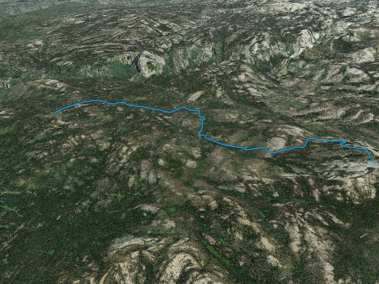
tours.snowlands.org/tours/13/1306tour.htm - use this for specifics on waypoints and trail info. Details from site below:
Description
Summary Link to more information about summary
Difficulty 4 Intermediate-advanced Length 10.1 miles one-way Starting Elevation 7250 feet Cumulative Elevation Change +1950, -700 one-way Navigation Road (groomed), marked trail and map Time Two days round trip Season Mid-December through early-April Snowmobiles Use Not permitted Please report illegal use of snowmobiles in this area. USGS Topo 7.5' series, El Capitan and Half Dome Start Badger Pass Ski Area on Glacier Point Road. The trailhead is located at the north end of the parking lot. Description Link to more information about description
The ranger station at Ostrander Lake is converted to a ski hut for the winter months and reservations are coveted for this backcountry hide-away that lies at the edge of the lake where the terrain rises abruptly to corniced Horse Ridge. After initially skiing along groomed Glacier Point Road the tour to the hut via Bridalveil Creek Trail winds through woods before a steep climb to a ridge and the hut on the edge of Ostrander Lake.
Image of Ostrander Lake and Horse Ridge Ostrander Lake and Horse Ridge from hut Ostrander Ski Hut accommodates 25 guests and the resident hut caretaker. A lottery each fall determines who gets the bunks for the following winter. For details contact:
The Yosemite Association P.O. Box 230 El Portal, CA 95318 209-379-2646 (phone) 209-379-2486 (fax) info@yosemite.org
Be aware that all the prime dates for the hut are taken during the lottery.
There are three distinct routes to Ostrander Ski Hut. Of the two primary trails, Bridalveil Creek Trail and Horizon Ridge Trail, the Bridalveil Creek Trail is slightly easier because it has slightly less elevation gain though it is 1.1 miles longer. In poor weather the Horizon Ridge Trail is often preferred because you spend more time skiing on groomed Glacier Point Road and it is shorter. But the price you pay is that you climb and descend an extra 350 feet and are more exposed to bad weather as you traverse the ridge.
The third route, the Merced Crest Trail, is significantly more difficult than either of the other trails.
You can combine Bridalveil Creek Trail and Horizon Ridge Trail to form a pleasant loop trip to and from Ostrander Ski Hut and enjoy considerable variation in terrain. If you choose Horizon Ridge for the return trip, the ridge offers an outstanding downhill run when the conditions are just right.
Most people take a full day to ski to or return from the hut. In fact, all routes are more difficult than you might expect and it is not uncommon for people to arrive after dark by headlamp. Get a very early start, preferably no later than 9 a.m., to avoid a late arrival and possible bivouac.
Image of shredded slope below Horse Ridge Fresh powder below Horse Ridge after a morning of skiing After the strenuous trip to the hut, you will want to plan one or two layover days to absorb the magnificent beauty of the area. The obvious day tour from the hut climbs onto Horse Ridge. An easier trip to the east will provide you with a stunning view of the ragged peaks of the Clark Range. The longer day trip to Buena Vista Peak can't be beat when the snow and weather conditions are favorable.
Image of skiers heading up to Horse Ridge Lower section of route up to Horse Ridge Mileage Log Link to more information about mileage log Numbers in parentheses correspond to mileage points on map
Waypoint 1 to 2 Miles: 0.0 - 0.7 Elevation change: +150, -50 feet
From the trailhead (1) ski northeast on the groomed trail and Glacier Point Road for 0.7 mile until you reach a high point (2). The first 50 yards is not actually on the road, but you will probably not notice the transition from the connecting trail to the road.
Waypoint 2 to 3 Miles: 0.7 - 1.0 Elevation change: -50 feet
Continue skiing on Glacier Point Road for 0.3 mile until you reach Summit Meadow (3).
Waypoint 3 to 4 Miles: 1.0 - 2.8 Elevation change: -350 feet
Continue skiing on Glacier Point Road for 1.8 miles until you reach the turnoff to Bridalveil Campground (closed in winter) and the Ghost Forest Trail (4). The Ghost Forest Trail intersects the Bridalveil Creek Trail at Lost Bear Meadow and although it can be used as an alternative route it is not described here.
Waypoint 4 to 5 Miles: 2.8 - 4.1 Elevation change: +150, -150 feet
Continue skiing on Glacier Point Road for 1.3 miles until you reach Bridalveil Creek Trail (5). The turnoff for Bridalveil Creek Trail is marked with a sign and the trail is designated as trail number 21.
Waypoint 5 to 6 Miles: 4.1 - 4.5 Elevation change: Nil
Turn south and follow the marked trail for 0.4 mile until you reach the east fork of Bridalveil Creek (6).
Waypoint 6 to 7 Miles: 4.5 - 5.5 Elevation change: +50 feet
Continue south on the marked trail for 1.0 mile until you reach the intersection with the Ghost Forest Trail (7) and a short distance before reaching Lost Bear Meadow. Lost Bear Meadow is very small.
Waypoint 7 to 8 Miles: 5.5 - 6.9 Elevation change: +100 feet
Continue on Bridalveil Creek Trail as it parallels the west fork of Bridalveil Creek for 1.4 miles until you reach the point where the trail begins to climb (8). Here you have covered 70 percent of the mileage but are 100 feet lower than where you started at Badger Pass Ski Area. In the next 3.2 miles you will climb 1500 feet and much of the time the trail will be steep.
Waypoint 8 to 12 Miles: 6.9 - 8.5 Elevation change: +800 feet
Continue on Bridalveil Creek Trail for 1.6 miles until you reach the intersection of the Bridalveil Creek Trail and the Horizon Ridge Trail (12).
Waypoint 12 to 13 Miles: 8.5 - 9.1 Elevation change: +450 feet
Continue southeast (right) on the combined trail, in about 50 yards you reach a large clearing that climbs southeast, and you ascend the clearing for a total of 0.6 mile until you reach the point where the trail turns abruptly southwest (right) (13) . The hill you climb is aptly called Heart Attack Hill. You will shortly come to a grand view to the east and north if you continue climbing southeast instead of turning. With the High Sierra as a backdrop, Mt. Starr King, Mt. Clark and the Clark Range lie before you.
Waypoint 13 to 14 Miles: 9.1 - 10.1 Elevation change: +250, -100 feet
Turn southwest (right) and follow the marked trail for 1.0 mile until you reach Ostrander Ski Hut (14) at Ostrander Lake.
Difficulty
Difficult
Serious gradient of 30-38 degrees where a real risk of slipping exists.
Low Exposure (E1)

Exposure is limited to that of the slope itself. Getting hurt is still likely if the slope is steep and/or the snow is hard.
Remoteness

Little chance of being seen or helped in case of an accident.
Best time to visit
Features
- Bowl
- Face
- Alpine
- Cliffs
- Tree Skiing
- Ski Mountaineering
Equipment required
- Skins
- Crampons