Ostrander Ski Hut (Merced Crest Trail)
Badger Pass Ski Area
Yosemite National Park
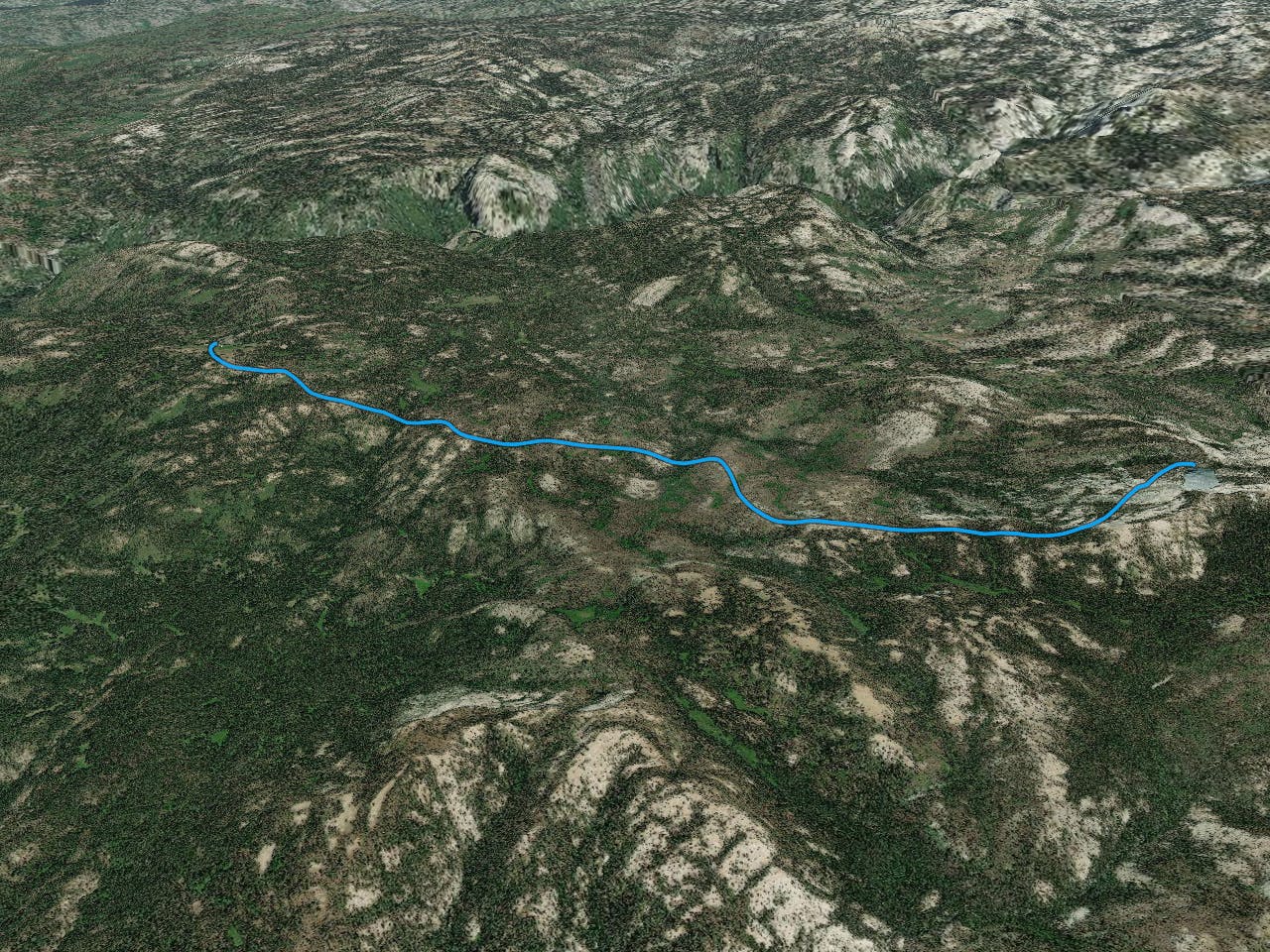
The Merced Crest Trail is one of three trails that lead from Badger Pass ski area to Ostrander ski hut, it is by far the most demanding of the three trails (others being Bridalveil Creek trail and Horizon Ridge trail).
Ski Touring Difficult
- Distance
- 13 km
- Ascent
- 1 km
- Descent
- 606 m
- Duration
- 5-6 hrs
- Low Point
- 2.2 km
- High Point
- 2.6 km
- Gradient
- 25˚
tours.snowlands.org/tours/13/1308tour.htm - use this for specifics on waypoints and trail info. Details from site below:
Description
Summary Link to more information about summary
Difficulty 4 Intermediate-advanced Length 8.4 miles one-way Starting Elevation 7250 feet Cumulative Elevation Change +2800, -1500 one-way Navigation Road (groomed), marked trail and map Time Two days round trip Season Mid-December through early-April Snowmobiles Use Not permitted Please report illegal use of snowmobiles in this area. USGS Topo 7.5' series, El Capitan, Mariposa Grove and Half Dome Start Badger Pass Ski Area on Glacier Point Road. Description Link to more information about description
The ranger station at Ostrander Lake is converted to a ski hut for the winter months and reservations are coveted for this backcountry hide-away that lies at the edge of the lake where the terrain rises abruptly to corniced Horse Ridge. The Merced Crest Trail is one of three trails that lead from Badger Pass Ski Area to Ostrander Ski Hut and is by far the most demanding because although it is the shortest route it has the most elevation gain. Bridalveil Creek Trail and Horizon Ridge Trail are the other two.
Although the most difficult, there are good reasons for choosing the Merced Crest Trail. For some, the difficulty is an irresistible challenge, and for everyone, there is incomparable solitude. Along this route, the trail traverses ridges with spectacular vistas and crosses three drainages that require care in descent and effort to ascend.
The Merced Crest Trail can be combined with either of the other two routes to Ostrander Ski Hut to form a loop. Even though the route described here is from Badger Pass Ski Area to the hut, this route is more commonly skied from the hut to the ski area in order to minimize the uphill climbing. This route is also more difficult to follow than the other two and is more exposed to the wind. It is best to ski this route in warm, fair weather when ice and route-finding are not problems.
Ostrander Ski Hut accommodates 25 guests and the resident hut caretaker. A lottery each fall determines who gets the bunks for the following winter. For details contact:
The Yosemite Association P.O. Box 230 El Portal, CA 95318 209-379-2646 (phone) 209-379-2486 (fax) info@yosemite.org
Be aware that all the prime dates for the hut are taken during the lottery.
Most people take a full day to ski to or return from the hut. In fact, all routes are more difficult than you might expect and it is not uncommon for people to arrive after dark by headlamp. Get a very early start, preferably no later than 9 a.m., to avoid a late arrival and possible bivouac.
After the strenuous trip to the hut, you will want to plan one or two layover days to absorb the magnificent beauty of the area. The obvious day tour from the hut climbs onto Horse Ridge. An easier trip to the east will provide you with a stunning view of the ragged peaks of the Clark Range. The longer day trip to Buena Vista Peak can't be beat when the snow and weather conditions are favorable.
Mileage Log Link to more information about mileage log Numbers in parentheses correspond to mileage points on map
Waypoint 1 to 2 Miles: 0.0 - 0.7 Elevation change: +550 feet
From the lodge at Badger Pass Ski Area (1) ascend parallel to the Red Fox and Eagle chairlifts for 0.7 mile until you reach the top of the lifts and the summit of Peak 7785 (2). Stay off the groomed slopes, or at least stay along the very edge, as you ascend. At the summit you will find a sign indicating that the Merced Crest Trail and Ostrander Lake are to the southeast.
Beyond this point you are on the Merced Crest Trail and it is designated as trail number 16.
Waypoint 2 to 3 Miles: 0.7 - 1.2 Elevation change: +150, -100 feet
Follow the trail east and then southeast along the broad ridge for a total of 0.5 mile until you reach Tempo Dome (3). The marked trail actually skirts the west side of Tempo Dome.
Waypoint 3 to 4 Miles: 1.2 - 1.5 Elevation change: -400 feet
Descend on the trail to the southeast for 0.3 mile until you reach a tree-filled saddle (4). This section is very steep.
Waypoint 4 to 5 Miles: 1.5 - 1.8 Elevation change: +150 feet
Climb gradually on the trail to the southeast for 0.3 mile until you reach a broad, open highpoint (5).
Waypoint 5 to 6 Miles: 1.8 - 2.4 Elevation change: -400 feet
Descend on the trail to the east, at first in a clearing and then in trees, for a total of 0.6 mile until you reach a saddle (6). The final part of the descent is quite steep and made more difficult by the trees. The saddle is the junction of the Merced Crest Trail and Limit Trail, and a sign on a tree indicates this this spot.
Waypoint 6 to 7 Miles: 2.4 - 3.6 Elevation change: +450 feet
Climb gradually southeast on the Merced Crest Trail for 1.2 miles until you reach the top of Peak 7625 (7) .
Waypoint 7 to 8 Miles: 3.6 - 4.4 Elevation change: -500 feet
Descend on the trail to the east for 0.8 mile until you reach a tributary of the west fork of Bridalveil Creek (8).
At the bottom of this third and final large drop, you have skied 4.4 miles or 50 percent of the total distance and are 150 feet lower than where you started at Badger Pass Ski Area. In the second half you must climb 1400 feet more.
Waypoint 8 to 9 Miles: 4.4 - 5.9 Elevation change: +950 feet
Following the trail, climb east to the low end of a ridge, then south and southeast on the ridge, often at a very steep angle, for a total of 1.5 miles until you reach level terrain at the west end of a broad ridge (9).
Waypoint 9 to 10 Miles: 5.9 - 7.0 Elevation change: +350, -50 feet
Ski east on the trail and broad ridge for 1.1 miles until you reach the point where the marked trail descends into a bowl to the northeast (10).
Waypoint 10 to 11 Miles: 7.0 - 8.4 Elevation change: +200, -50 feet
Descend northeast into the bowl along the trail, then climb gradually northeast past the bowl, then veer slightly more east for a total of 1.4 miles until you reach Ostrander Lake and Ostrander Ski Hut (11) located on its north shore.
Difficulty
Difficult
Serious gradient of 30-38 degrees where a real risk of slipping exists.
Low Exposure (E1)

Exposure is limited to that of the slope itself. Getting hurt is still likely if the slope is steep and/or the snow is hard.
Remoteness

Little chance of being seen or helped in case of an accident.
Best time to visit
Features
- Alpine
- Cliffs
- Tree Skiing
- Ski Mountaineering
Equipment required
- Skins
- Crampons