43 m away
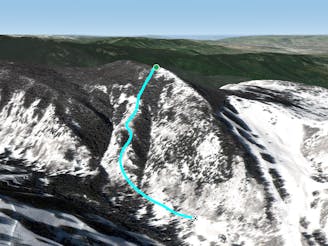
Upper Alta

Beautiful pow face that rides off the ridge
Difficult Freeride Skiing
- Distance
- 183 m
- Ascent
- 0 m
- Descent
- 85 m
Sssh, don't tell anyone
Freeride Skiing Difficult

For a more reliable and safer descent, drop right of the rest aspect into either chute atop King Arthur and have fun exploring this steep open tree terrain. Be sure to have a “safety” meeting with Andrew before takeoff. The left line is the most common with juicy face shots and modest ledge drops. At the bottom, cut right to seek additional soft lines; let your mind and boards explore before you join the cat trail that takes you back to Grouse.
Difficult
Serious gradient of 30-38 degrees where a real risk of slipping exists.

As well as the slope itself, there are some obstacles (such as rock outcrops) which could aggravate injury.

Little chance of being seen or helped in case of an accident.
43 m away
Beautiful pow face that rides off the ridge
Difficult Freeride Skiing
134 m away

Avy prone ski chute that is a blast when conditions are right
Severe Freeride Skiing
469 m away

Technical chute and bowl faces that command your attention
Moderate Freeride Skiing
471 m away

Tight trees that turn into fresh fields
Difficult Freeride Skiing
627 m away

The elk gullet that let's you run wild
Difficult Freeride Skiing
647 m away

Accessible freshies from the top of Grouse
Difficult Freeride Skiing
749 m away

A powder chase through 3 fields
Difficult Freeride Skiing
764 m away

An elysian powder field atop Grouse into Royal Elk
Difficult Freeride Skiing
1.7 km away
A stoic sunny ridge ride down drainage #2 of the Y Chutes
Difficult Freeride Skiing
1.8 km away

A high-risk and unfriendly face
Severe Freeride Skiing